Location
Lat 3° 14' 8S 127° 5' 60E Old Namlea Airfield is located at 4' above sea level to the north of Namlea on the eastern coast of Boeroe Island in the Molucca Island Group (Molucca Islands). Prewar and during the Pacific War, located in the Netherlands East Indies (NEI). Today located in Maluku Province in Indonesia.
Construction
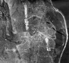
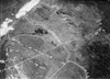
Built by the Dutch prior to the war as a secondary airfield.
The airfield had two parallel landing strips: runway No. 2 and runway no. 4. Both were connected by two shorter runways designated runway no. 1 and runway no. 3.
Wartime History
Until January 1942, used by the Dutch and the Royal Australian Air Force (RAAF) as a military airfield. Afterwards, occupied by the Japanese and used as a military airfield.
Starting in February 1944 until January 1945 attacked by Allied aircraft. Occupied by the Japanese until the official surrender of Japan in September 1945.
American missions against Namlea
February 4, 1944–January 3, 1945
Today
The eastern runway is still in use today as Namlea Airport. Airport codes: ICAO: WAPR, IATA: NAM.
References
Index to Air Bases - Research Report No. 85, I.G. No 9185 - July 30, 1944
Contribute
Information
Do you have photos or additional information to add?
Last Updated
April 19, 2025
|