|
|
|
|
| Missing In Action (MIA) | Prisoners Of War (POW) | Unexploded Ordnance (UXO) |
| Chronology | Locations | Aircraft | Ships | Submit Info | How You Can Help | Donate |
|
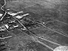 20th AF c1945 |
Location Lat 35° 40' 18N Long 139° 31' 41E Chōfu Airfield is located at an elevation of 141' above sea level to the west of Chofu (Chofugaoka) in the Kantō Region on Honshū Island in Japan. In Japanese spelled Chōfu Hikōjō. In English spelled as Chofu Airfield. To the east is Tokyo. Construction During 1938, the Japanese Army Air Force (JAAF) planned to build an airfield at this location. Construction began in 1939 and was opened by 1941 with two runways: the first 1000 meters in length and the second 675 meters in length. By 1944, the runways were expanded to 4,500' and 4,200' with concrete hangars added to protect parked aircraft. Wartime History Used by the Japanese Army Air Force (JAAF) as a military airfield. Starting in July 1945 attacked by U.S. aircraft until the end of the Pacific War. American missions against Chofu Airfield July 8, 1945–August 7, 1945 Postwar On September 27, 1945 occupied by the U.S. Army Air Force (USAAF) and based both the 6th Photographic Reconnaissance Group (6th PRG) and 71st Reconnaissance Group both operating the F-5 Lightning photo-reconnaissance aircraft to map wartime damage in Japan until January 1946. Afterwards, turned over to the occupation government and later returned to Japanese control. Today Still in use today as Chofu Airport. Airport code: ICAO: RJTF. Used by a variety of aviation companies including Aerotec, Jamco, JAXA, Toho Air Service, Tokyo Airlines and New Central Air Service. Today, two of the 1944 concrete hangars are preserved in a nearby park. References Survey of Japanese Airfields in the Empire Area. CinCPac-CinCPOA Sept. 1944 Contribute
Information Last Updated
|
Map Fallingrain Photo Archive |
| Discussion Forum | Daily Updates | Reviews | Museums | Interviews & Oral Histories |
|