|
|
|
|
| Missing In Action (MIA) | Prisoners Of War (POW) | Unexploded Ordnance (UXO) |
| Chronology | Locations | Aircraft | Ships | Submit Info | How You Can Help | Donate |
|
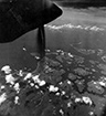 USAAF December 1943 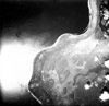 8th PRS c1944 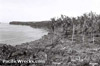 US Army c1944  Mark Reichman 2008 |
Location Lat 6° 7' 60S Long 149° 7' 0E Arawe Airfield is located near Lupin inland from Cape Ainto on the southwestern of New Britain. To the northeast is Aivalo and to the southwest is Meselia. Located about 4-5 miles east of Arawe (Cape Merkus). Pronounced "Ara-wee". Also known as "Lupin" or "Lupon". Construction Prewar, a landing ground was cleared at this location as a civilian emergency landing strip for aircraft flying from Lae bound for Rabaul. It is unknown if any aircraft landed at this strip, or if it was simply built as a precaution for any flight emergencies. By 1942, the runway was overgrown and unservicable. Wartime History During 1943, occupied by the Japanese. Barges were used to transport fuel to this location, possibly in preparation for use as a forward airfield or emergency strip. Possibly, the runway was used by Japanese aircraft as an emergency strip or for very limited operations. Richard Dunn adds: "By mid-1943 Gasmata Airfield was already untenable due to Allied raids. If there ever was any thought of developing Merkus as an operational airfield, it was no doubt abandoned by that time." On December 15, 1943, when the U.S. Army landed at Arawe, the Japanese incorrectly believed Arawe Airfield was their objective. When reinforcements including tanks were landed, the defending Japanese were ordered to retreat to the vicinity of the airfield until the 112th Calvary attacked and occupied the area. Afterwards, Arawe Airfield was never developed by the Allies or used by Allied aircraft. Today There is a new airstrip built by a timber company at a different angle in the same general area, known as "Lupon Airfield". Also spelled "Lupin Airfield". This runway runs roughly east-north-east to west-south-west direction, parallel to the coastline, and in a different location than the prewar built landing ground. Mark Reichman adds: "I got a story from a guy from Pililo Island in the Arawes across from Amalut where the landing was. He said there was an airstrip called "Kasauna" which is by the village of Meselia which is on the coast west of the Pulie River. There is a timber company airstrip there now but the new airstrip is at a different angle from the WWII strip and only touches the tip of the old airstrip. He said the Japanese built it. It sounds like the same one. The report says the strip was some 4 miles to the east of defense area (Amalut) and they called it, Lupin Airdrome. I have a map that shows a village some 4 miles away from the landing at Amalut called Lupon. My informant said Kasauna is the name of the area the strip was at close by Lupon Village so it must be the same." References Tuluvu's Air War: Chapter IX: Landing in Western New Britain by Richard Dunn Thanks to Brian Bennett for additional information Contribute
Information Last Updated
|
Map Fallingrain February 1, 1944 Survey Map 1970 View in Google Earth (Lupin) Photo Archive |
| Discussion Forum | Daily Updates | Reviews | Museums | Interviews & Oral Histories |
|