|
|
|
|
| Missing In Action (MIA) | Prisoners Of War (POW) | Unexploded Ordnance (UXO) |
| Chronology | Locations | Aircraft | Ships | Submit Info | How You Can Help | Donate |
|
 5th AF March 12, 1944  5th AF March 20, 1944  Ray Fairfield 1966 |
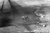
Location Lat 6° 4' 54S Long 145° 23' 31E Goroka Airfield is located near Goroka (Garoka). Also spelled Garoka Airfield. Prewar and during the Pacific War located in the Territory of New Guinea. Today located in the Eastern Highlands Province of Papua New Guinea (PNG). Still in use today as Goroka Airport. Construction Built prewar by the Australian administration as a single runway surfaced with grass. Wartime History In the middle of 1942 the single runway measured 950' x 10' x 5200' surfaced with grass. Facilities included a government station, 100 man barracks, food and W. O. Upson based at the airfield. Could be lengthened 50 yards. On June 29, 1943 expanded for military use by U.S. Army engineers supervised by the engineer sections from the Australian Army 2/2 Independent Company and 2/7 Independent Company. With the help of over 1,000 native laborers, a 600' single runway with dispersal bays was made operational in only seven days on July 6, 1943. By late July 1943, spotted by the Japanese and targeted by Japanese bombers and reconnaissance planes. Japanese missions against Goroka Airfield July 30, 1943–September 2, 1943 On December 21, 1945 lost is Avro Anson AX443 crashed on take off due to a cross wind without injury to the crew or passengers but the damaged plane was written off and abandoned. Today Still in use today as Goroka Airport with daily service by Air Niugini and other airlines. The runway measures 1,646m x 30m at an elevation of 1,646'. Airport codes: ICAO: AYGA and IATA: GKA. References Notes about New Guinea airfields, recorded circa May - July, 1942 by Oliver C. Doan via Jean Doan research Edward Rogers 4th Kokugun Takes Charge by Richard Dunn page 8 NAC - Goroka Airport Contribute
Information Last Updated
|
Map 1943 Map Fallingrain Map Mapcarta View in Google Earth Photo Archive |
| Discussion Forum | Daily Updates | Reviews | Museums | Interviews & Oral Histories |
|