|
|
|
|
| Missing In Action (MIA) | Prisoners Of War (POW) | Unexploded Ordnance (UXO) |
| Chronology | Locations | Aircraft | Ships | Submit Info | How You Can Help | Donate |
|
 5th AF c1943 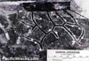 5th AF Sept 6, 1943 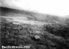 RAAF Dec 21, 1943 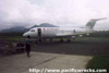 Phil Bradley 2001 |
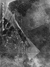
Location Lat 5° 27' 44S Long 150° 24' 18E Hoskins Airfield is located at an elevation of 40' above sea level near Gavuvu on Cape Hoskins on the north coast of New Britain. The northwestern end borders Stettin Bay. To the southwest is Gavuvu. During the Pacific War, known to the Japanese as "Gabubu Airfield" or "Gavuvu Airfield" for nearby Gavuvu. Known to the Allies as Hoskins Airfield or Cape Hoskins Airfield. Prewar and during the Pacific War located located in the Territory of New Guinea. Still in use today as Hoskins Airport located in West New Britain Province in Papua New Guinea (PNG). Also known as simply "Hoskins". Construction Built by the Japanese as a single runway measuring 4,000' in length as of October 18, 1943 with the northwest edge bordering Stettin Bay. The southwest side of the runway had the control tower plus taxiways and thirty fighter revetments. Hoskin Airfield was defended by anti-aircraft guns. Wartime History Used by the Japanese as a military airfield by the Imperial Japanese Navy (IJN) for fighters and bombers. American missions against Hoskins Airfield September 19, 1943–March 26, 1944 Wartime History Used as a forward Japanese airfield. Attacked by Allied aircraft during late 1943 until March 1944. In early May 1944 captured by U.S. Marines from 1st Marine Division. Several Japanese aircraft were captured relatively intact at the airfield including D3A2 Val Tail 82-224 and D4Y1 Judy Tail 01-070. Today Still used today as Hoskins Airport classifed as a small airport by Air Niugini to provide air service to the Kimbe area of Western New Britain Province with connecting flights to Tokua Airport. Airport codes: ICAO: AYHK, IATA: HKN. The single runway 30/12 measuring 5,212' x 98' (1,585m x 30m). During early August 2002, Hoskins Airport was temporarily closed due to the eruption of a nearby volcano. Reportedly work was done to survey Talasea Airfield as an alternate landing ground for the area but it was never implemented. After the eruption, Hoskins Airport was undamaged and remains in use to this day. References NAC - Hoskins Airport Contribute
Information Last Updated
|
Map Fallingrain Map Mapcarta Photo Archive |
| Discussion Forum | Daily Updates | Reviews | Museums | Interviews & Oral Histories |
|