|
|
|
|
| Missing In Action (MIA) | Prisoners Of War (POW) | Unexploded Ordnance (UXO) |
| Chronology | Locations | Aircraft | Ships | Submit Info | How You Can Help | Donate |
|
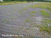 John Douglas 2006 |
Location Lat 7° 25' 28S 144° 15' 0E Kikori Airfield is located at an elevation of 50' above sea level to the south of Kikori inland from the southern coast of New Guinea. Prewar and during the Pacific War located in the Territory of Papua. Today located in the Kikori District of Gulf Province in Papua New Guinea. Construction Built postwar as a single runway surfaced with grass. Later, the runway was surfaced with surplus U.S. Army marston matting (PSP). Colin Richardson adds: "Until about 1965, Kikori was served by a war-surplus PBY Catalinas until it became unserviceable. It was this I think that forced the rehab of the old airport. (I lived about 400m south of the airport). The marston matting there today is a recent addition. In my boyhood the airstrip was bare clay and mud, overgrown in places, with no matting at all. Then it was repaired, surfaced with tarmac, and opened to traffic (about 1967). Tarmac was considered necessary because Kikori has one of the highest rainfalls in the country - average (at the airstrip) some 360 inches per year (my actual measurements 1964-69 as a student). Clearly it didn't last. I visited Kikori in 2000, and found the marston matting as illustrated - it had been added sometime since 1969." Today Still in use today as Kikori Airport serviced by local airlines or charter flights. Airport Codes: ICAO: AYKK IATA: KRI. Contribute
Information Last Updated
|
Map Fallingrain View in Google Earth |
| Discussion Forum | Daily Updates | Reviews | Museums | Interviews & Oral Histories |
|