|
|
|
|
| Missing In Action (MIA) | Prisoners Of War (POW) | Unexploded Ordnance (UXO) |
| Chronology | Locations | Aircraft | Ships | Submit Info | How You Can Help | Donate |
|
 IJN February 8, 1943  5th AF Oct 12, 1943 |
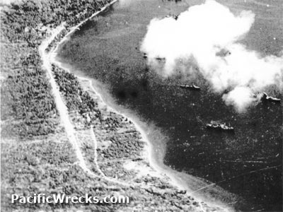
Location Malaguna Airfield was located at Malaguna along the road adjacent to Simpson Harbor to the northeast is Rabaul. Also known as "Emergency Airfield". Today located in East New Britain Province in Papua New Guinea (PNG). Construction By early 1943, built by the Japanese as a single runway parallel to Malaguna Road. It is possible this was simply an expansion of the road and not a runway, but Allied intelligence noted it as a runway. Wartime History During the Pacific War, Malaguna Airfield might have been used as an emergency crash strip. Storage tunnels were dug into the nearby ridge to disperse stores likely unloaded from vessels that could anchor nearby. American missions against Malaguna January 14, 1944–April 13, 1944 Today Disused as an airfield since the war. Today, it is part of the Kokopo Road, located near the present day overseas wharf. In the shortage tunnels near this airfield, airplane parts were discovered during the 1980s. Contribute
Information Last Updated
|
Map March 18, 1943 Map Nov 2, 1943 View on Google Earth Photo Archive |
| Discussion Forum | Daily Updates | Reviews | Museums | Interviews & Oral Histories |
|