|
|
|
|
| Missing In Action (MIA) | Prisoners Of War (POW) | Unexploded Ordnance (UXO) |
| Chronology | Locations | Aircraft | Ships | Submit Info | How You Can Help | Donate |
|
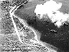 IJN February 8, 1943  USAAF Oct 12, 1943  Steve Saunders 2001 |
Location Lat 4° 13' 0S Long 152° 9' 0E Malaguna is located on the Gazelle Peninsula at the northeastern tip of New Britain. Borders Simpson Harbor to the east, Vulcan (Rakaia) to the south and three miles to the north is Rabaul. Today, there are three villages located on the shoreline: Malaguna 1, Malaguna 2 and Malaguna 3. The section of road at this location was known as "Malaguna Road", today known as the "Kokopo Road". Between 1884 until September 1914 part of Deutsch Neu Guinea (German New Guinea). Prewar and during the Pacific War part of the New Britain District in the Territory of New Guinea. Today located in East New Britain Province of Papua New Guinea (PNG). Today, there are three villages located on the shoreline: Malaguna 1, Malaguna 2 and Malaguna 3. Wartime History On January 23, 1942 after midnight, the Japanese Army "South Seas Detachment" built around 144th Infantry Regiment landed and several locations including Malaguna and occupied the area. During the Pacific War, many tunnels were dug in this area by the Japanese and the coastline bordering Simpson Harbor used by barges and ships and a seaplane operating area known as Malaguna Seaplane Base. A section of parallel to Malaguna Road was developed into Malaguna Airfield and used as an emergency strip. Between 1942-1945 the Malaguna area was attacked by Allied bombers and fighters. Allied missions against Malaguna January 14, 1944–April 13, 1944 Occupied by the Japanese until the end of the Pacific War. On September 10, 1945, after the official surrender the day before, Australian 29/46 Infantry Battalion 4 Infantry Brigade landed at Malaguna, the first troops of the Allied occupational force to land in the area. Japanese Anti-Aircraft Battery Malaguna Airfield (Malaguna Emergency Strip) Malaguna Seaplane Base Malaguna Tunnels Brian
Bennett reports: During July 2001, a rain storm collapsed a Japanese tunnel between Malaguna 1 and Malaguna 2 near a gas station with Japanese hydrovanes stored inside. Contribute
Information Last Updated
|
Map Fallingrain |
| Discussion Forum | Daily Updates | Reviews | Museums | Interviews & Oral Histories |
|