|
|
|
|
| Missing In Action (MIA) | Prisoners Of War (POW) | Unexploded Ordnance (UXO) |
| Chronology | Locations | Aircraft | Ships | Submit Info | How You Can Help | Donate |
|
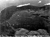  5th CCU Jan 5, 1943   USAAF Nov 2, 1943 |
Location Vulcan is a pumice cone volcano located at the edge of Simpson Harbor and Karavia Bay. To the north is Malaguna and Rabaul. Also known as Vulcan Crater or Vulcan Volcano. Known as Rakaia in the local language. Also known as Mount Rakaia or Rakaia Volcano. Prewar Originally, known as Vulcan Island surrounded by Karavia Bay until an eruption connected it to the mainland. During 1937, Vulcan and Tavurvur erupted covering the Rabaul area with ash. Wartime History On January 23, 1942 after midnight the Japanese Army "South Seas Detachment" made an amphibious landing near the northern edge of Vulcan. During the Japanese occupation of Rabaul, the vicinity of Vulcan was used a a hideout for barges also described as barge stalls. Attacked by Allied aircraft during 1943-1944. Occupied by the Japanese until the official surrender of Japan in September 1945. American missions against Vulcan May 25, 1944–October 5, 1944 F4U-1D Corsair Serial Number NZ5415 Pilot Davies crashed January 30, 1945 near the crater of Vulcan, remains recovered postwar Today On September 19, 1994 a simultaneous eruption of Tavurvur and Vulcan began that spewed ash over the entire Rabaul area. Afterwards, minor eruptions continued. Today, Vulcan is quite and the slopes are covered in vegetation. Contribute
Information Last Updated
|
Map November 2, 1943 |
| Discussion Forum | Daily Updates | Reviews | Museums | Interviews & Oral Histories |
|