 |
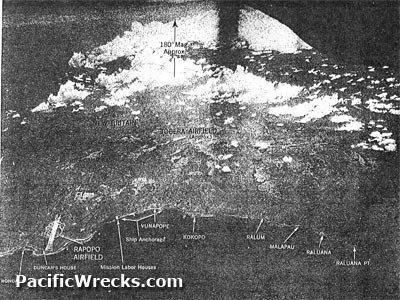
Aerial view of Rapopo Airfield looking 180 degrees (southward)
Annotated from left to right is Duncan's House (at the tip of Lesson Point), Rapopo Airfield, Mission Labor House, ship anchorage (located between Rapopo to Vunapope), Vunapope, Kokopo, Ralum, Malapau, Raluana, Raluana Point (Schulze Point) bordering Blanche Bay. At the upper right is the right engine and propeller of the photographic-reconnaissance F-4 Lightning that took the photograph.
Credit: USAAF, 5th AF Date: February 22, 1943
B&W
High Resolution Version
Acquire This Image |
Contribute Information
Do you have photos or additional information?
Previous Page
|
|