|
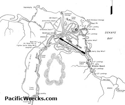
Map of Saidor and Saidor Airfield on the north coast of New Guinea
The line indicates the north coast of New Guinea including Saui Point and beyond to the east Dekays Bay. Enlargement Saidor Airfield. To the northeast is Saui Point and Saui Beaches with LST landings, fuel jetty, lighter wharf and Liberty Ship wharf. To the southeast is Wilwilan with Lagap Beach with LST landings, PT jetty and beyond and Wilwilan Beach with two LST landing areas.
Credit: U.S. Army Date: 1944
Map
High Resolution Version
Acquire This Image |
Contribute Information
Do you have photos or additional information?
Previous Page
|
|