|
|
|
|
| Missing In Action (MIA) | Prisoners Of War (POW) | Unexploded Ordnance (UXO) |
| Chronology | Locations | Aircraft | Ships | Submit Info | How You Can Help | Donate |
|
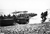 U.S. Army Jan 2, 1944 |
Location Dekays Bay is located off the north coast of New Guinea bordering Sawoi (Saui) and inland to the southwest is Saidor. Prewar and during the Pacific War part of the Madang District in the Territory of New Guinea. Today, located in the Rai Coast District, Madang Province in Papua New Guinea (PNG). Wartime History On January 2, 1944 at dawn, U.S. Task Force "Operation Michaelmas" enters Dekays Bay. Nine destroyers including USS Beale (DD-471), USS Mahan (DD-364), USS Drayton (DD-366), USS Lamson (DD-367), USS Flusser (DD-368), USS Reid (DD-369), USS Smith (DD-378) and USS Hutchins (DD-476) commence a preinvasion shore bombardment firing a total of 1,725 5" shells at the landing area and targets. Next LCI(R) fire 624 4.5" rockets at the landing beaches and points inland from Sawoi (Saui). Bad weather prevents preparatory air strikes but over 80 B-24s, B-25s and A-20 bomb Saidor Airfield and areas inland from the landing beaches. At 7:25am the first wave of LCVP landing craft land after a slight delay due to bad weather land at Saui Beaches designated Red Beach, White Beach and Blue Beach. Over seventeen minutes, four waves of landing craft land 1,440 soldiers. Sixteen LCI land another 3,000 soldiers. There was no opposition on the beach as the U.S. Army, 6th Army, 32nd Infantry Division, 126th Regimental Combat Team (126th RCT) under the command of General Martin with the 120th Field Artillery plus other elements from the 32nd Infantry Division went ashore. Japanese aerial opposition was ineffective but did result in one killed and several wounded plus two sailors drown. References U.S. Army in World War II - Cartwheel: The Reduction of Rabaul Chapter XIV Crossing the Straits pages 298, 300 The 32D Infantry Division in World War II The ‘Red Arrow’ The New Guinea Campaign - Saidor Contribute
Information Last Updated
|
Map January 2, 1944 Map 1944 Map Mapcarta Photo Archive |
| Discussion Forum | Daily Updates | Reviews | Museums | Interviews & Oral Histories |
|