|
|
|
|
| Missing In Action (MIA) | Prisoners Of War (POW) | Unexploded Ordnance (UXO) |
| Chronology | Locations | Aircraft | Ships | Submit Info | How You Can Help | Donate |
|
 Google Earth 2022 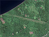 Google Earth 2022 |
Location Lat 4° 58' 0S Long 151° 18' 0E. Sule Airfield (Ubili Airfield) is located at an elevation of 100' above sea level southwest of Sule near Mount Uluwan on the north coast of New Britain. To the southwest is Ubili and Ulamona. Allied references refer to this location as "Ubili Airfield". Prewar and during the Pacific War part of the Territory of New Guinea. Postwar, remained in use as Sule Airport in West New Britain Province in Papua New Guinea (PNG). Construction During the middle of 1943 built by the Imperial Japanese Navy (IJN) as a single runway running roughly east to west. Wartime History On June 5, 1943 a photographic reconnaissance F-5 "Eager Beaver" 42-13073 piloted by 1st Lt. Frederic G. Hargesheimer observed a "new airfield" at this location and photographed the area. The School That Fell From the Sky, page 35-36: "Off to the right, I spotted what looked like the construction of a new airfield. I leveled off and circled the area for a better look. The least I could do was shoot a set of pictures and let the photo interpreters back at the base decide if this was an important field. I carefully lined up for a low-altitude pass over what looked like a runway and set the camera intervelometer for a series of overlapping pictures." Used by the Japanese to a limited capacity. It is unlikely any aircraft were based here, but used the runway for refueling or emergency landings during the middle of 1943. Afterwards, abandoned. Postwar Remained in use postwar as Sule Airport. Airport code: IATA: ULE. Used by light aircraft. Today The runway appears to be partially overgrown and is not being maintained. Ray Fairfield adds: "That was the wartime strip running down to the water, AFAIK. The Ki-21 Sally tail was just next to the strip, and two Zero carcasses, in very poor shape, in the bush at the inland end. Again, only one short visit." John Douglas adds: "I visited this strip in 2000. There was a sawmill nearby. Only found a piece of wreckage, no intact wrecks. I have been there twice. I've never explored it properly though. There is some Japanese undercarriage parts at the landward end, little else. I've never met any locals who knew what was there." Cecilie Benjamin adds: "Sule is not used these days (perhaps for small aircraft for the logging)." References Thanks to Richard Dunn and Ray Fairfield for additional information Contribute
Information Last Updated
|
Map Fallingrain Map Mapcarta View in Google Earth |
| Discussion Forum | Daily Updates | Reviews | Museums | Interviews & Oral Histories |
|