|
|
|
|
| Missing In Action (MIA) | Prisoners Of War (POW) | Unexploded Ordnance (UXO) |
| Chronology | Locations | Aircraft | Ships | Submit Info | How You Can Help | Donate |
|
 USN 1942 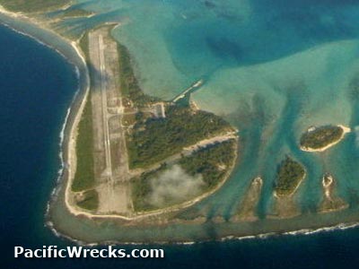 1990 |
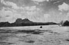
Location Lat 16° 26' 40S Long 151° 45' 5W Bora Bora Airfield is located at an elevation of 10' above sea level on Motu Mute Island in Bora Bora Atoll in the Society Islands (Archipel de la Société) of French Polynesia (Polynésie Française). Named for nearby Bora Bora Island (Pora Pora). Also known as Motu Mute Airfield. Construction During early 1943, built by U.S. Navy (USN) Naval Construction Battalion (NCB) "Seabees" as a single runway oriented roughly northwest to southeast surfaced with crushed coral. Wartime History During 1943, Bora Bora Airfield was used by the 7th Air Force (7th AF). Robert Rocker adds: "The 7th Air Force kept a Squadron of P-40 Warhawks there during the war on garrison duty along with some US Navy floatplanes so the Japanese could not invade the island. One day one of these P-40's was flying a patrol and was given a radar vector of a bogey and he set course to check it out it turned out to be a Emily Flying Boat coming to recon Bora Bora and the P-40 shot it down do you know anything about this story it is the only story in the whole Pacific War where a Army Air Force fighter shot down a Japanese flying boat." Today Still in use today as Bora Bora Airport. Classified as a small airport with two runways. The first oriented 29/11 measures 4,921' x 72' surfaced with asphalt. The second oriented 35/17 measures 3,000' x 140' surfaced with coral. Airport codes: ICAO: NTTB IATA: BOB. Serviced by Air Tahiti. References Air Tahiti - History of the company "It was not until the Second World War that aviation really took off, with the construction of the first airstrip, in 1943, in Bora Bora, by the US military." Contribute
Information Last Updated
|
Map Fallingrain Map Mapcarta |
| Discussion Forum | Daily Updates | Reviews | Museums | Interviews & Oral Histories |
|