|
|
|
|
| Missing In Action (MIA) | Prisoners Of War (POW) | Unexploded Ordnance (UXO) |
| Chronology | Locations | Aircraft | Ships | Submit Info | How You Can Help | Donate |
|
 USN October 19, 1943 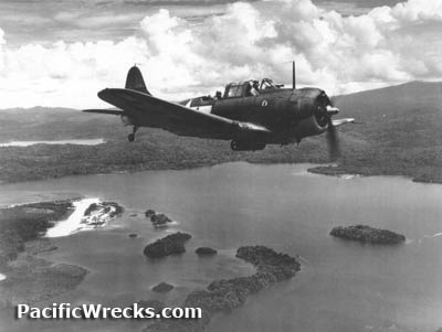 USN December 10, 1943 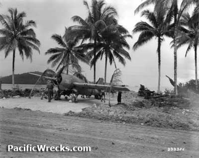 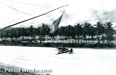 USN c1943 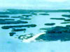 USAAF c1944  1988 via Rocker 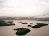 Paul Sodemann 1999 |
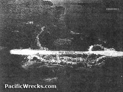
Location Segi Airfield is located at Segi (Seghe) on the southern tip of New Georgia. Also known as Segi Point Airfield or Segi Field. To the east is the entrance of Morovo Lagoon. Borders Panga Bay and the Njai Pass to the northeast. Located 40 miles from Munda. Prewar and during the Pacific War part of the British Solomon Islands Protectorate (BSIP). Still in use today as Seghe Airport or Sege Airport in Western Province in the Solomon Islands. Also spelled Sege Airport. Prewar Segi plantation was established at this location planted with coconut palm trees harvesting copra. Construction On June 21, 1943 a survey team from U.S. Navy (USN) ACORN 7, 47th Naval Construction Battalion (47th NCB) "Seabees" began construction of a single runway surfaced with crushed coral at this location. On June 30, 1943 construction began by the 20th Naval Construction Battalion (20th NCB) "Seabees" using bulldozers and power shovels and flood lights to work overnight. By July 11, 1943 a single runway measuring 3,000' x 300' oriented roughly east to west for use as an emergency landing strip and limited operations. Afterwards, taxiways and revetments were built to the north and south of the runway. Wartime History Starting in the middle of July 1943, American aircraft began using Segi as a forward base that was the most forward American base on New Georgia until Munda Airfield was captured and became operational. During this period, Segi was used for emergency landings or to land and refuel for fighters based on Guadalcanal. During July 1943 to September 1943 Segi was used by U.S. Army Air Force (USAAF) P-39N Airacobras from the 12th Fighter Squadron (12th FS), 44th Fighter Squadron (44th FS) "Vampire Squadron" and 68th Fighter Squadron (68th FS). Starting in the middle of August 1943 American fighters began operating from Munda Airfield. During October 1943 until late November 1943 used by U.S. Navy (USN) F6F Hellcats. American units based at Segi Airfield (partial list) U.S. Army Air Force (USAAF) 925th AAA Automatic Weapons Battalion 18th FG, 44th FS (P-40s) July 1943–August 1943 U.S. Navy (USN) 47th Naval Construction Battalion (47th NCB) "Seabees", C Company VF-38 (12 x F6F) October 1943 - ? VF-40 (12 x F6F) October 1943 - ? VF-33 (24 x F6F) Nov 1 - Nov 29, 1943 Veteran Frank Ruscavage recalls: "I served on Segi point in 1944. Navy Seabees constructed the airbase, I was with the 925th AAA AW BN. The Navy planes that flew from Segi were SBD bombers & Grumman Corsairs, I believe there were called 'the flying duck'. The Japs on Bougainville made a counter push to recapture the air field, they got pretty close of doing so, all planes were ordered to different airfields in the region, the P-38's to Segi, the airfield on Segi was long enough to land the plane but they had to touch down at the very beginning of the strip, the 1st three planes didn't and went into the water, the other planes (about 12) landed safely. The month was I think was in June 1944." Earl F. Long recalls: "I was based at Segi Point In 1944, I was in a C.A.S.U. outfit and we serviced SBD's, we were later transfered to Munda Airfield and was attached to a TBF Squadron." Don Anderson reports: “My father [47th Construction Battalion, C Company] helped build the airstrip at Seghe Point in WWII, all the veterans call Segi Point, pronouncing it 'Seegee'. I visited there in the summer of 1993. I left a plaque with a picture of the landing, CB Logo, info, and papers on the back with the names of the 47th Seabees at the small police outpost by the end of the strip. I landed on the strip and went to Uepi. I came back in motorized canoe and dove on the P-38. It was right where my dad said it would be. However, the said the P-38’s were trying to land and the runway was short for them. The first made it but the second ran into the back of it and pushed it into the water. I think this can be verified. Look at the back of the P-38. It is bent under. This would be where the other plane hit it. My dad said the planes were running out of fuel trying to get back to Henderson Field on Guadalcanal. The tower told them the runway was too short for them. A P-38 radioed back that it was try or land in the ocean. The tower told them to come on. I have many photographs my dad took, but no scanner. The pilot quarters were down by the water. The rest were up on the hill along with the guns. I found some buried barrels on the hill. I took pictures and video. I got laughed at when I got home. They would put an outhouse over these buried drums. When they got full, They put the top on it and moved the outhouse somewhere else. You will notice that there is a dugout area closed to the strip. This was a dug officer swimming pool. I notice canoes are docked inside it now to get off the ocean. I think they used marston mat on a hole in the side for the water to go in and out. My dad said this was so an officer didn't get attacked by a shark. He said they swam and bathed in the ocean. A shark wouldn't eat an enlisted man.” Today Still in use today as Seghe Airport or Sege Airport. The runway is overgrown with grass. Airport codes: ICAO: AGGS IATA: EGM. Served by Solomon Airlines (Fly Solomons) for domestic flights to Honiara Airport. During 2013, the New Zealand Government funded the resurfacing of the runway. A memorial plaque dedicated August 15, 2013 was placed at the terminal building. References History of the U.S. Marine Corps Operations in World War II - Chapter 2 pages 59, 63, 64, 65, 67, 69, 70, 71, 73, 78, 79 U.S. Army in WWII The Reduction of Rabaul Chapter VI Toenails: The Landings in New Georgia pages 81, 82 (photo), 84-85 Contribute
Information Last Updated
|
Map June 21, 1943 Map Oct 15, 1943 Map Fallingrain View in Google Earth Photo Archive |
| Discussion Forum | Daily Updates | Reviews | Museums | Interviews & Oral Histories |
|