|
|
|
|
| Missing In Action (MIA) | Prisoners Of War (POW) | Unexploded Ordnance (UXO) |
| Chronology | Locations | Aircraft | Ships | Submit Info | How You Can Help | Donate |
|
 USAAF July 8, 1944  USAAF 1944 |
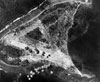
Location Lat 7° 22' 35N Long 143° 54' 29E Woleai Airfield is located on Woleai Island (Falalap) in Woleai Atoll in Yap State in the Federated States of Micronesia. Also known as Falalap Airfield. Construction Built by the Japanese who cleared the entire island to construct a single runway measuring 3,290' x 330' running roughly northeast to southwest. A taxiway 2,050' x 165' ran north to south. Wartime History Used by the Japanese as a military airfield. During April 1944 until April 1945 attacked by American aircraft. Occupied by the Japanese until the official surrender of Japan. American missions against Woleai Airfield (Falalap) April 1, 1944–April 27, 1945 D3A Val Reportedly bomb blasted on its nose A6M Zero Wreckage Today Still in use today as Woleai Airport (Woleai Atoll Airport). Contribute
Information Last Updated
|
February 25, 1944 Map Fallingrain View in Google Earth Photo Archive |
| Discussion Forum | Daily Updates | Reviews | Museums | Interviews & Oral Histories |
|