|
|
|
|
| Missing In Action (MIA) | Prisoners Of War (POW) | Unexploded Ordnance (UXO) |
| Chronology | Locations | Aircraft | Ships | Submit Info | How You Can Help | Donate |
|
 IJN c1942 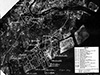 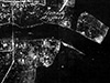 USAAF April 29, 1945  USN 1945 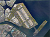 Google Earth Jan 9, 2018 |
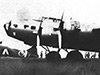
Location Lat 35° 33' 8N Long 139° 46' 47E Haneda Airfield is located on a man made island in Tokyo Bay to the south of Tokyo. Still in use today as Haneda Airport. Also known as Tokyo International Airport or in Japanese as Tōkyō Kokusai Kūkō 東京国際空港. Borders Kawasaki to the south. Construction Built prewar as a commercial airport serving the the Tokyo area. Wartime History During July 1942, captured Allied aircraft were displayed for the public at the airfield, including B-17D Flying Fortress 40-3095. During 1944-1945, this airfield was used in the defense of Tokyo. Postwar Americans used it for USN air transport command, for all overseas flights in and out of Japan. After the occupation, the airport was returned to the Japanese as a commercial airport. By the 1960s, Haneda Airport was close to densely-populated residential and industrial areas, began to suffer from capacity and noise issues that resulted in the Japanese government seeking a site for a new airport to serve the Tokyo area that resulted in Narita Airport opening in 1978. Today Still in use today as Haneda Airport or Tokyo International Airport. Haneda has three runways. The first runway is oriented 22/04 measures 8,200' x 200' surfaced with asphalt. The second oriented 34L/16R measured 9,840' x 200' surfaced with asphalt. The third oriented 34R/16L measures 9,840' x 200' surfaced with asphalt. Airport codes: ICAO: RJTT / IATA: HND. References Haneda Airport - Official Website Contribute
Information Last Updated
|
Map 1945 Map Fallingrain Photo Archive |
| Discussion Forum | Daily Updates | Reviews | Museums | Interviews & Oral Histories |
|