|
Location
Lat 5° 49' 36S Long 144° 17' 45E Mount Hagen Airfield is located at an elevation of 5,363' to the east of Mount Hagen in the Western Highlands Province in Papua New Guinea.
Construction
Built during 1934, the third landing ground built at Mount Hagen. Previously, two other landing grounds had been established Kelua Airfield and Mogei Airfield (Mogai) but both were disused in favor of this location east of the town.
Prewar
Mount Hagen Airfield was used by missionaries and the Australian administration for air service to Mount Hagen.
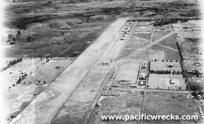
World War II Pacific Theatre History
During the middle 1942 a single runway 1100 x 70 x 5600' surfaced with hard dry earth. (Two auxiliary airfields obstructed) manned by W.O. L.G.R. Kyongdon, 300 barrels of 80 octane + empty drums. Facilities described as barracks for 100 men, radio equipment and excellent approaches.
Used during the war primarily by US Army C-47s to transport food grown in the area to forward bases.
Today
Still in use today, known as "Mount Hagen Airport". Also known as "Kagamuga Mt Hagen". The single runway measures 2,190m x 30m. Airport codes: ICAO: AYMH, IATA: HGU.
References
Notes about New Guinea airfields, recorded circa May - July, 1942 by Oliver C. Doan via J. Doan / E. Rogers
National Airports Comission (NAC) - Mt Hagen Airport
Contribute
Information
Do you have photos or additional information to add?
Last Updated
April 19, 2021
|