|
|
|
|
| Missing In Action (MIA) | Prisoners Of War (POW) | Unexploded Ordnance (UXO) |
| Chronology | Locations | Aircraft | Ships | Submit Info | How You Can Help | Donate |
|
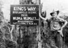 Roy Preston 1945 |
Location Lat 5° 52' 11" S Long 155° 13' 53" E Numa Numa village is located at an elevation of 39' / 12m above sea level on the eastern coast of Bougainville. Also spelled Numanuma (one word) or Numa-Numa (with hyphen). Borders Numa Numa Harbor. At Numa Numa is the start of the Numa Numa Trail a prewar walking track across the island. Prewar and during the Pacific War, part of the Kieta District in the Territory of New Guinea. Today located in the Central Bougainville District in the Autonomous Region of Bougainville (AROB) in Papua New Guinea (PNG). Wartime History During 1942 occupied by the Japanese Army and developed into a base and staging area. Starting in the middle of 1943 until the end of the Pacific War, attacked by Allied aircraft. By July 1945, Australian patrols reached the coast at Numa Numa, but the village remained occupied by the Japanese until September 1945. American missions against Numa Numa May 31, 1943–May 17, 1944 Numa Numa Trail (Numanuma Trail) Prewar walking track that spanned from Numa Numa on the eastern coast of Bougainville across the central mountain range to the western coast. References Australian Army Campaigns in New Guinea: Bougainville Contribute
Information Last Updated
|
Map Mapcarta |
| Discussion Forum | Daily Updates | Reviews | Museums | Interviews & Oral Histories |
|