|
|
|
|
| Missing In Action (MIA) | Prisoners Of War (POW) | Unexploded Ordnance (UXO) |
| Chronology | Locations | Aircraft | Ships | Submit Info | How You Can Help | Donate |
|
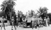 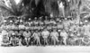 British Army c1942 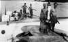 RAF April 30, 1946  Jared Grimmer 2005  Jared Grimmer 2005 |
Location Lat 7° 18′ 48″ S Long 72° 24′ 40″ E Diego Garcia Island is the largest island in the Chagos Archipelago (Chagos Islands) south of the equator in the Indian Ocean. Discovered by Portuguese explorers in the early 1500s and named Diego Garcia. In the 1790s settled by the French then after the Napoleonic Wars transfered to the British. Prewar and during the Pacific War, Diego Garcia was a dependency under the the British Colony of Mauritius. During 1965, the Chagos Islands were detached and became part of the British Indian Ocean Territory (BIOT) administered by the United Kingdom. Wartime History On May 1941 a Catalina piloted by 1st Lt. Alex Jardine landed in the lagoon. During March 1942 a PanAm "Capetown Clipper" flyingboat landed in the lagoon carrying Lt. Col Herman H. Pohl, US Army Corps of Engineers and his subordinate who toured the island to assess the feasibility of building an airfiineld Eclipse Point. The British Navy began fortifying Diego Garcia, code named "Port 2Y" as an alternate Navy base in case the Japanese occupied Ceylon. Also, they developed the base as a refueling location Navy warships and Advance Flyingboat Base 29 (AFB 29). During March 1942 a detachment of Royal Marines led by Captain J. Alan Thompson emplaced two 6" guns to defend the lagoon. A single road built around the island. Those who died on the island from disease and accidents were buried at Point Marianne cemetery on the island. During the Pacific War, the island was garrisoned by a force of British, Mauritian and Indian soldiers. On July 26, 1942 offshore Japanese submarine I-16 performs a reconnaissance of Diego Garcia. By the end of April 1946 the last Allied personnel depart Diego Garcia. Today In 1965, the British Indian Ocean Territory (BIOT) was created to provide administrative control of the area. In December of 1966, the United Kingdom and the United States signed a bilateral agreement making the islands of the BIOT available for defense purposes for both governments. Diego Garcia Seaplane Base (Advance Flyingboat Base 29) Located at East Point on Diego Garcia, seaplanes landed into the adjacent lagoon. Catalina IIA "Katie" Registration VA718 Squadron Code K Pilot Park grounded September 16, 1944 6" Naval Gun One of two naval gun emplaced on the northwest tip of Diego Garcia at Eclipse Bay, today known as "Cannon Point". Diego Garcia Airport (NAF Diego Garcia) Located on the western arm of Diego Garcia built during 1971 References Peak of Limuria The Story of Diego Garcia (1993) pages 4, 31, 62-72 Contribute
Information Last Updated
|
Map Prewar Map Fallingrain |
| Discussion Forum | Daily Updates | Reviews | Museums | Interviews & Oral Histories |
|