|
|
|
|
| Missing In Action (MIA) | Prisoners Of War (POW) | Unexploded Ordnance (UXO) |
| Chronology | Locations | Aircraft | Ships | Submit Info | How You Can Help | Donate |
|
 Google Earth 2015 |
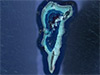
Location Lat 0° 49' 60N Long 134° 19' 60E Mapia Island Group (Mapia Islands, Mapia Atoll) was previously known as Freewill Islands or Saint David’s Islands. Includes Bras Island (Berasi), Pegun Island (Mapia), Fanildo Island, Bras Kecil (Little Bras) and Fanildo Kecil (Little Fanildo). Located to the north of the equator. To the south is Biak Island and Manokwari 290 km away. Palau 630 km to the west. Today, known as Kepulauan Mapia in Bahasa Indonesian. Today, located in present day Supiori Regency, Papua Province in Indonesia. Wartime History Occupied by the Japanese. In early August 1944 targeted by American bombers and fighters. American missions againt Mapia Island Group August 2, 1944–November 18, 1944 During November 15, 1944, elements of the U.S. Army 31st Infantry Division, 167th Infantry Regiment made an amphibious landing at Mapia Island (Pegun Island). Those defenders who were not killed, fled into the jungle and most died of starvation. Bras Island (Berasi) Main island in the Mapia Island Group, in the northeast of the atoll. Pegun Island (Mapia) Main island in the Mapia Island Group, in the southeast of the atoll. Also known as Mapia Island or Pulau Pegun. Today, there is a small settlement on the southern portion of the island. References Pub. 164 Sailing Direction (Enroute) New Guinea page 251 Contribute
Information Last Updated
|
Map Fallingrain |
| Discussion Forum | Daily Updates | Reviews | Museums | Interviews & Oral Histories |
|