|
|
|
|
| Missing In Action (MIA) | Prisoners Of War (POW) | Unexploded Ordnance (UXO) |
| Chronology | Locations | Aircraft | Ships | Submit Info | How You Can Help | Donate |
|
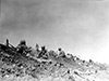 USMC May 19, 1945 |
Location Lat 26° 14' 34N Long 127° 43' 19E Awacha 安波茶 is located at an elevation of 85' / 25m in roughly the center of the southern Okinawa Island in Okinawa Prefecture of Japan. Also known as Ahacha or Afuwacha. To the southwest is Dakeshi and beyond Wama and o the south is Shuri. The terrain at this location is broken by hills and ridges and during the Battle of Okinawa was known as the "Awacha Pocket". Wartime History After the U.S. landings on Okinawa, the Japanese defended the Awacha area. During early May 1945, the strong Japanese defenses in this area were dubbed the Awacha Pocket" for their tenacious defense against U.S. Marines (USMC) advancing from the west and U.S. Army 77th Division advancing from the north. On May 2, 1945 the U.S. Marines advanced in heavy rain and after seizing the nearest high ground came under intense fire from adjacent strong points and had to withdraw. During the night, the Marines engaged in hand-to-hand combat with Japanese infiltrators and one survivor commented on the upcoming combat "This is going to be a bitch". After three days of bitter fighting, the Marines managed to seal off the pocket. On May 6, 1945 in the morning, four battalions of U.S. artillery (two Army and two Marine) bombardment the pocket before the 5th Marines launched their morning attack. On May 10, 1945 the 5th Marines finally cleared the Awacha Pocket, concluding a week of fighting often at point-blank range and claimed more than 1,000 Japanese killed. References The Final Campaign: Marines in the Victory on Okinawa pages 28 (map), 29, 30, 33 Contribute
Information Last Updated
|
Map May 1-3, 1945 Map Fallingrain |
| Discussion Forum | Daily Updates | Reviews | Museums | Interviews & Oral Histories |
|