|
|
|
|
| Missing In Action (MIA) | Prisoners Of War (POW) | Unexploded Ordnance (UXO) |
| Chronology | Locations | Aircraft | Ships | Submit Info | How You Can Help | Donate |
|
 6th Mar Div April1, 1945 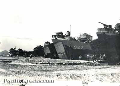 USN April 1945 |
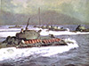
Location Lat 26° 20' 15N Long 127° 48' 9E Okinawa Island is the largest island in the the Okinawa Island Group (Okinawa Island) in the Ryukyu Islands (Nansei Shoto) of Okinawa Prefecture in Japan. Also known as Okinawa-hontō, Okinawa Jima or simply Okinawa. Borders the Philippine Sea to the east and East China Sea to the west. Roughly 700 miles to the south is the Philippines, and only 300 miles to the north is the southern tip of the mainland of Japan. To the northwest is Ie Shima. Wartime History During the Pacific War, Okinawa was an developed with military airfields and installations. Starting in October 1944, targeted by U.S. planes until the invasion then as air support for ground forces. American missions against Okinawa October 10, 1944–April 1, 1945 On April 1, 1945 at 08:30am L-Day American forces land at Hagushi beaches on the western coast of Okinawa including U.S. Marines (USMC) III Amphibious Corps and U.S. Army XXIV Corps over a wide area spanning from Bolo Point (Cape Zanpa) to the north past Kadena to Camp Foster to the south. Today, there is a commemorative marker for the invasion at Chatan-cho. Meanwhile, the 2nd Marine Division conducted a feign landing off Minatoga to the southeast to deceive the Japanese. By the end of the day 60,000 Americans were ashore and encounter little resistance but suffered 28 casualties mostly due to friendly fire. Offshore, the U.S. Navy warships and transports were targeted by Japanese kamikaze aircraft. Starting the day of the invasion, Japanese planes attack U.S. warships and transports offshore with conventional attacks and kamikaze attacks until the end of the Pacific War. During the Battle of Okinawa, U.S. vessels are targeted by Japanese suicide boats, mines and shore batteries. On April 5, 1945 the Imperial Japanese Navy launched Operation Ten-Go (Operation Heaven Number One): with The Surface Special Attack Unit including Battleship Yamato on a one way mission to attack the U.S. fleet then beach on western Okinawa with any surviving crew joining the Japanese defenders ashore. On April 7, 1945 during the Battle of the East China Sea attacked by U.S. Navy carrier planes and sunk and never reach Okinawa. Japanese missions against Okinawa April 1, 1945–June 22, 1945 The Battle of Okinawa lasted 82 days from the initial invasion on April 1, 1945 until the island was officially declared secure on June 22, 1945. In total, the Americans lost 12,520 KIA and 38,000-55,000 WIA. The Japanese lost between 77,166 KIA (US estimated 110,000 KIA) and more than 7,000 captured as POWs. The civilian population of Okinawans and Japanese suffered between 40,000 to 150,000 killed, committed suicide or missing. Postwar Okinawa remained under U.S. military control until 1972 when returned to Japan. Okinawa Island Locations Naha (Nawa, Nafa) located in the southwestern corner of Okinawa, largest city includes Naha Airfield. Shuri (Shui, Syuri) located in the center of southern Okinawa, site of Shuri Castle. Shuri Castle (Shuri-jo) located at Shuri used by the Japanese Army to defend southern Okinawa Moshinawa (Machinato) located in the center of the western coast of Okinawa, Moshinawa Airfield. Awacha 安波茶 (Ahacha, Afuwacha) located to east of Moshinawa (Machinato) in southern Okinawa. Sobe (Subi, Suhi) located on the western coast toward the center of Okinawa includes Yontan Airfield. Kadena (Katena) located on the western coast toward the center of Okinawa includes Kadena Airfield. Itoman (Ichuman) located in the southern Okinawa including Buckner Monument and Peace Memorial Museum. Yonabaru (Yonahara, Yunabaru, Yonawa) located on the eastern coast of southern Okinawa. Chimu (Kin, Kinmu, Chin, Kimmu, Kimu) located on the eastern coast of southern Okinawa. Urasoe located to the north of Naha includes Kakuazu Ridge. Kakazu 嘉数 (Kakuazu) located Maeda 前田 (Meida, Meda) located Hagushi located on the west coast of Okinawa to the north of Kadena Airfield. Cape Zanpa (Bolo Point) located on the western coast of Okinawa. Chatan located on the western coast includes commemorative marker for the April 1, 1945 invasion beaches Minatoga (Minatogawa) located on the southeast of Okinawa 2nd Mar Div feign landing Tomori (Tomoi, Tomui, Domui, Tumui) located on the southern coast of Okinawa. Nakagusuku Bay (Buckner Bay) located on the southeastern coast of Okinawa. Chimu Bay (Kin Bay) located off the eastern coast of Okinawa. Hagushi Bay (Hagushi Anchorage) located off Yomitan (Yontan) off the mouth of the Bishi River (Hija River). Yanbaru Region 山原 encompasses the northern portion of Okinawa. Motobu Peninsula located on the eastern coast of Okinawa. Mount Yae (Mount Yaedake, Yae-Take) highest elevation on the Motobu Peninsula. Unten 運天 located on the northeast tip of the Motobu Peninsula. Nago 名護市 located at the base of the Motobu Peninsula on the center of eastern Okinawa. Okinawa Island Airfields Naha Airfield (Oroku) still in use today as Naha Airport Bolo Airfield located at Bolo Point on the western coast of Okinawa. Moshinawa Airfield (Machinato) located near Naha. Yontan Airfield (Yomitan, Yonzan) located near Sobe on the western coast of Okinawa. Kadena Airfield (Kadena AFB) located at Kadena near Yontan on the western coast of Okinawa. Yonabaru Airfield (NAS Yonabaru) located near Yonabaru on the eastern coast of the southern Okinawa Island. Motobu Airfield located on the Motobu Peninsula on the western coast of Okinawa. Futema Airfield located on the center of Okinawa. Awase Airfield located on the eastern coast of Okinawa. Chimu Airfield located on the eastern coast of Okinawa. Chimu Seaplane Base established by the USN in July 1945 until hit by typhoons in September-October 1945 References The New York Times "1945: The Battle of Okinawa Ends" June 22, 1945 Contribute
Information Last Updated
|
Map Archive Map April 16, 1945 Map Dec 31, 1945 Map Okinawa Prefecture |
| Discussion Forum | Daily Updates | Reviews | Museums | Interviews & Oral Histories |
|