|
|
|
|
| Missing In Action (MIA) | Prisoners Of War (POW) | Unexploded Ordnance (UXO) |
| Chronology | Locations | Aircraft | Ships | Submit Info | How You Can Help | Donate |
|
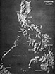 U.S. Army 1944 |
Location The Philippines is an archipelago of islands in the western Pacific Ocean. Officially, the Republic of the Philippines. Also abbreviated PI. Manila is the largest city and national capital located in the National Capital Region (NCR) of Luzon. The Philippines includes 7,641 islands in three geographical divisions: Luzon in the north, Visayas (Visayas Islands) in the center and Mindanao in the south. Borders the South China Sea to the west, Philippine Sea to the east, Celebes Sea to the south and Sulu Sea to the southwest. Today, the Philippines shares maritime borders with Taiwan to the north, Japan to the northeast, Vietnam and China to the west, Palau to the east plus Malaysia and Indonesia to the south. Wartime History On December 8, 1941 Japanese aircraft attacked Luzon and later in the month the Japanese Army landed on northern Luzon defeating U.S. Army and Filipino defenders. After being evacuated, U.S. Army General Douglas MacArthur vowed "I shall return". After the surrender of U.S. and Filipino forces, the Japanese occupied the Philippines. During the Japanese occupation, Filipino guerrillas opposed the occupation. On May 6, 1943 a Japanese state visit was made by Prime Minister of Japan Hideki Tojo made an official state visit to the Philippines, landing at Nichols Field at Manila and during a speech, pledged to establish a Japanese-sponsored Philippine Republic. On October 14, 1943 the Japanese established the Republic of the Philippines (Second Philippine Republic) as a puppet state under President José P. Laurel. By late 1944, Allied forces had advanced to within range of the Philippines allowing aircraft to attack targets ahead of the liberation. On October 20, 1944 the Americans landed on eastern Leyte starting the liberation of the Philippines. The Japanese responded and between October 23-26, 1944 was a series of battles associated with the Battle of Leyte Gulf. On December 15, 1944 the Americans landed on Mindoro. On January 9, 1945 the Americans landed at Lingayen Gulf starting the liberation of Luzon. The remaining Japanese forces a protracted defense to delay and tie up the American forces that continued to liberate occupied locations until the official surrender of Japan. During the Pacific War, nearly every location in the Philippines was impacted by World War II either directly or indirectly. On July 4, 1946 the Republic of the Philippines gained full independence from the United States. Philippines Islands Luzon largest and most populous island in the Philippines includes the capital city of Manila. Batanes Island Group (Batanes Islands) located to the north of Luzon. Leyte located in the Visayas Islands in the central Philippines. Samar located in the eastern Visayas Islands in the central Philippines. Cebu located in the eastern Visayas Islands in the central Philippines. Panay located in the western Visayas Islands in the central Philippines. Guimaras in the Western Islands in the central Philippines. Negros in the Visayas Islands, fourth largest island in the Philippines. Mindoro located to the southwest of Luzon and to the northeast of Palawan. Tablas located in Mimaropa Regionto the southeast of Mindoro Island. Palawan located in Mimaropa Region in Palawan Province. Lubang located in the Lubang Island Group (Lubang Islands) to the southwest of Luzon. Masbate located in the Bicol Region to the southeast of Luzon. Catanduanes located in the Bicol Region to the southeast of Luzon. Bohol located in the Central Visayas. Mindanao located in the south of the Philippines. Dinagat located in the south of the Philippines. Philippines Regions Region I (Ilocos Region) includes Illocos Notre, Ilocos Sur, La Union and Pangasinan. Region II (Cagayan Valley Region) includes Batanes, Cagayan, Isabela, Nueva Vizcaya, Quirino and Quirino. Region III (Central Luzon Region) includes Aurora, Bataan, Bulacan, Nueva Ecija, Pampanga, Tarlac, Zambales. Region IV (Southern Tagalog) former region that became the National Capital Region (NCR). Region IV-A (Calabarzon Region) Region IV-B (Mimaropa) located in the southwest Philippines. Region V (Bicol Region) includes Camarines Sur, Albay and Sorsogon. Region VI (Western Visayas) includes Panay and Negros Occidental. Region VII (Central Visayas) includes Cebu, Bohol, Negros Oriental, and Siquijor. Region VIII (Eastern Visayas) located in the eastern Visayas includes Leyte, Samar and Biliran. Region IX (Western Mindanao) Region X (Northern Mindanao) Region XI (Southern Mindano) Region XII (Autonomous Region In Muslim Mindanao, ARMM) central western Mindanao and Sulu Islands. Region XIII (Caraga Administrative Region) Philippines Bodies of Water Philippine Sea located to the east of the Philippines site of the Battle of the Philippine Sea. Surigao Strait located in the southern Philippines between the Mindanao Sea (Bohol Sea) and the Leyte Gulf. Leyte Gulf located in the southern Philippines bordering Leyte and Samar. Visayan Sea located in the Visayas in the central Philippines. Sibuyan Sea located in the Visayas in the central Philippines. Surigao Strait located in the Visayas in the central Philippines. Mindoro Strait located to the west of Mindoro Island in the Philippines. Jintotolo Channel (Jintotolo Strait) connects the Sibuyan Sea with the Visayan Sea between Panay and Masbate. Sulu Sea located to the southwest of the Philippines bordering Palawan, Panay, Negros and Mindanao. Philippines Regions and Provinces National Capital Region (NCR) Manila (City of Manila) national capital of the Philippines. Ilocos Region (Region I) Illocos Notre Province located on the northwest of Luzon. Ilocos Sur Province located on the western coast of Luzon. La Union Province located on the northwest of Luzon. Pangasinan Province located on the northwest of Luzon. Cagayan Valley Region (Region II) Batanes Province located Batanes Island Group (Batanes Islands). Cagayan Province located in the Cagayan Valley of northeast of Luzon. Isabela Province mountain province located at the center of Luzon. Nueva Vizcaya Province located in the Cagayan Valley in central-northern Luzon. Quirino Province located in the Cagayan Valley of northeast of Luzon. Cordillera Administrative Region (CAR) Abra Province located in northern Luzon bordering Ilocos Norte to the west. Apayao Province located in northern Luzon bordering Ilocos Norte to the west and Cagayan to the east. Benguet Province located in northern Luzon including Baguio. Ifugao Province located in northern Luzon where Japanese retreated. Kalinga Province located in northern Luzon bordering Cagayan to the northeast. Mountain Province located in northern Luzon in the Cordillera Mountains. Central Luzon Region (Region III) Aurora Province located on the eastern coast of central Luzon. Bataan Province includes the Bataan Peninsula on western Luzon. Bulacan Province located in central Luzon. Nueva Ecija Province located in central Luzon. Pampanga Province located in central Luzon. Tarlac Province located in central Luzon. Zambales Province located in central Luzon. Calabarzon Region (Region IV-A) Cavite Province located on the Cavite Peninsula bordering Manila Bay and offshore islands. Laguna Province located in the southwestern of Luzon includes Laguna de Bay. Batangas Province located in the southwestern of Luzon. Rizal Province located in southern Luzon borders Laguna de Bay. Quezon Province located southeast of Manila in the southwest of Luzon. Southwestern Tagalog Region (Mimaropa, formerly Region IV-B) Marinduque Province Occidental Mindoro Province Oriental Mindoro Province Palawan Province encompasses Palawan Island and adjacent islands. Puerto Princesa located inside Palawan Province. Romblon Province includes Romblon Group of Islands (Romblon Islands) including Tablas Island. Bicol Region (Region V) Albay Province located at the southeastern of Luzon bordering Albay Gulf. Camarines Norte Province located at the southeastern of Luzon. Camarines Sur Province located at the southeastern of Luzon. Sorsogon Province located in the southern Philippines. Catanduanes Province encompasses Catanduanes Island. Masbate Province offshore island province. Western Visayas Region (Region VI) Iloilo Province southern portion of Panay Island including Ilo Ilo (Iloilo City). Antique Province located on the eastern portion of Panay Island. Guimaras Province encompasses Guimaras Island. Negros Occidental Province northwest portion of Negros Island. Central Visayas Region (Region VII) Negros Oriental Province southeastern portion of Negros Island. Iloilo Province southern portion of Panay Island including Ilo Ilo (Iloilo City). Bohol Province encompasses Bohol Island in the Central Visayas. Eastern Visayas Region (Region VIII) Biliran Province includes Biliran Island in Eastern Visayas (Region VIII). Leyte Province (Northern Leyte Province) northern half of Leyte in Eastern Visayas Region (Region VIII). Southern Leyte Province southern half of Leyte in Eastern Visayas Region (Region VIII). Northern Samar Province northern portion of Samar Island in Eastern Visayas Region (Region VIII). Samar Province (Western Samar Province) southern portion of Samar in Eastern Visayas Region (Region VIII). Eastern Samar Province eastern portion of Samar Island in Eastern Visayas Region (Region VIII). Zamboanga Peninsula Region (Western Mindanao, Region IX) Sulu Province includes the northeast of the Sulu Archipelago. Zamboanga del Norte Province Zamboanga Sibugay Province located on the south coast of the Zamboanga Peninsula on western Mindanao. Zamboanga del Sur Province Northern Mindanao Region (Region X) Bukidnon Province Camiguin Province Misamis Occidental Province Misamis Oriental Province Lanao del Norte Province Davao Region (Southern Mindanao Region, Region XI) Davao de Oro Province Davao del Norte Province Davao del Sur Province Davao Oriental Province Davao Occidental Province Autonomous Region In Muslim Mindanao (ARMM, Region XII) Basilana Province located in the Bangsamoro Autonomous Region (BARMM). Lanao del Sur Province located in the Bangsamoro Autonomous Region (BARMM). Maguindanao Province located on the southwestern coast of Mindanao. Tawi-Tawi Province includes the islands at the southwest of the Sulu Archipelago. Caraga Administrative Region (Region XIII) Dinagat Islands Province includes the Dinagat Islands in the Caraga Administrative Region (Region XIII). Contribute
Information Last Updated
|
Map 1945 Map Fallingrain Map Mapcarta |
| Discussion Forum | Daily Updates | Reviews | Museums | Interviews & Oral Histories |
|