|
|
|
|
| Missing In Action (MIA) | Prisoners Of War (POW) | Unexploded Ordnance (UXO) |
| Chronology | Locations | Aircraft | Ships | Submit Info | How You Can Help | Donate |
|
 U.S. Army 1944 |
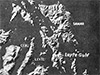
Location Samar Island is located in the Eastern Visayas (Region VIII) in the Visayas (Visayas Islands) in the central Philippines. Today divided between three provinces: Northern Samar Province, Samar Province (Western Samar Province), Eastern Samar Province. To the southeast is Calicoan Island. To the southwest is Leyte Island and to the south borders Leyte Gulf. Today, connected by the San Juanico Bridge (Marcos Bridge) to Tacloban on Leyte. Northern Samar Province located in northern Samar Island. Samar Province (Western Samar Province) located in western Samar Island. Eastern Samar Province located in eastern Samar Island. Battle Off Samar The Battle Off Samar was part of the Battle of Leyte Gulf. During the night of October 24-25, 1944 the Japanese "Central Force" made a night passage through San Bernardino Strait. Shortly after dawn the Japanese opened fire on TG 77.4 escort carriers and escorts. During the battle, USS Gambier Bay and two destroyers and USS Samuel B. Roberts DE-413 was sunk by Japanese gunfire. Three Japanese heavy cruisers were sunk by carrier aircraft. Contribute
Information Last Updated
|
Map Oct 20, 1944 Map Fallingrain |
| Discussion Forum | Daily Updates | Reviews | Museums | Interviews & Oral Histories |
|