|
|
|
|
| Missing In Action (MIA) | Prisoners Of War (POW) | Unexploded Ordnance (UXO) |
| Chronology | Locations | Aircraft | Ships | Submit Info | How You Can Help | Donate |
|
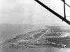  USAAF c1944  Jack Heyn 1945 |
Location Lat 11° 14' 36N Long 125° 0' 17E Tacloban is located on the northeast of Leyte in Leyte Province in the Eastern Visayas (Region VIII) in the Visayas (Visayas Islands) in the central Philippines. Also known as Taclaban, Tocloban or Dakuban. Borders Cancabato Bay. To the northwest is the southern entrance to the San Juanico Strait. To the east borders San Pedro Bay and beyond Leyte Gulf. Connected by Highway 1 that runs north to south. To the north is the bridge connecting to Samar. To the south is Palo and beyond Tanauan and Dulag. Today known as Tacloban City designated as a 1st class highly urbanized city within Leyte Province and is connected via the San Juanico Bridge (Marcos Bridge) to Samar Province on Samar Island. Wartime History During 1942, occupied by the Japanese who referred to this location as "Tacroban". On October 20, 1944 liberated by the U.S. Army. Tacloban was developed into a major American airfield designated U.S. Army Post Office 72 (APO 72). Base K (Leyte / Tacloban) US Army Letter Base designation base located at Tacloban. Tacloban Airfield (Daniel Z. Romualdez Airport) Built prewar used by the United States 1944–1945, still in use today Leyte Provincial Capitol Located on Sen. Eñage Street fronting Plaza Liberated and the University of the Philippines Visayas Tacloban. Built in 1907, it is the seat of the provincial government of Leyte. Historic viewing of mural depicting the First Mass in Limasawa in the Orient and General Douglas MacArthur landing on Leyte. The Leyte Provincial Capitol became the seat of the Commonwealth Government of the Philippines after President Sergio Osmeña, Sr. returned with General Douglas MacArthur to Leyte. Price Mansion Located on Justice Romualdez St., Tacloban City. An example of the American colonial home built in 1990. Sturdy mansion where Gen. Mac Arthur put up his official headquarters and residence when he came with the Liberation forces in October 20, 1944. Redona Residence The Redona Residence is located on T. Claudio Street, Tacloban City. During late October 1944, this house became the official residence of President Osmeña, Sr. when he returned to the Philippines with U.S. forces and was used until the Philippine Commonwealth government was reestablished in Manila. References X U.S. Army in World War II The War in the Pacific Leyte: The Return to the Philippines Chapter IV The Return pages 45, 50, 52 (33rd IR Palo and Tacloban), 57 U.S. Army in World War II The War in the Pacific Leyte: The Return to the Philippines Chapter V A Day: 20 October 1944 pages 62, 63, 64 (map), 65, 67, 72, 78 Contribute
Information Last Updated
|
Map Oct 20, 1944 Map X Corps Oct 20, 1944 Map Fallingrain Photo Archive |
| Discussion Forum | Daily Updates | Reviews | Museums | Interviews & Oral Histories |
|