|
|
|
|
| Missing In Action (MIA) | Prisoners Of War (POW) | Unexploded Ordnance (UXO) |
| Chronology | Locations | Aircraft | Ships | Submit Info | How You Can Help | Donate |
|
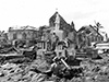 U.S. Army October 1944 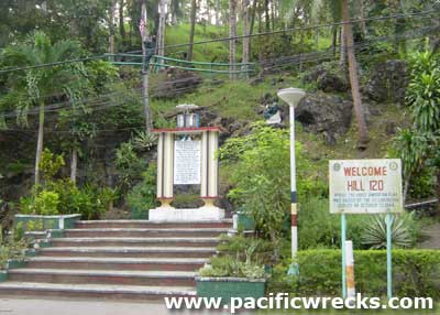 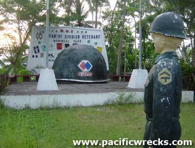 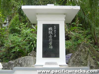 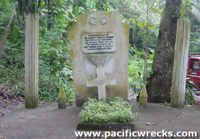 Justin Taylan 2004 |
Location Lat 10° 57' 9N Long 125° 1' 54E Dulag is located at an elevation of 3' on the eastern coast of Leyte Province on Leyte Island in the Eastern Visayas Region (Region VIII) in the central Philippines. To the east borders Leyte Gulf. Connected by Highway 1 that runs north to south. To the north San Jose, San Roque and beyond Tanauan, Palo and Tacloban. To the south is Dao and beyond Abuyog. Another road inland spans westwards to Julita and beyond Burauen then northward to Dagami. Today officially the Municipality of Dulag. Wartime History By 1944, the Japanese concluded that the Americans would make an amphibious landing in the Dulag area. By late 1944, the 16th Division under the command of General Makino ordered the 20th Infantry Regiment commanded by Col. Keijiro Hokoda plus elements of the 22d Field Artillery Regiment, 54th Air Field Company commanded by Comdr. Kazumasa Kumazawa and Type 89 I-Go tanks from 7th Independent Tank Company. On October 20, 1944 the preliminary naval bombardment forced the Japanese to withdraw from the landing beaches and damaged the town. At 10:00am Dulag was the site of the initial landing by the U.S. Army XXIV Corps including the 96th Infantry Division and 7th Infantry Division. After the landing, Major General John R. Hodge established his staff at corps headquarters in Dulag. On October 21, 1944 at 3:00am General Makino ordered the remaining defenders to withdraw from the Dulag area inland to Dagami. Meanwhile, Major General John R. Hodge ordered the 7th Division to advance westward westward along the along the Dulag-Burauen and by the end of the day they had captured Dulag Airfield and advanced beyond further to the west. Our Lady of Refuge Church The Catholic Our Lady of Refuge church was originally built in the 16th century by the Jesuits as a church made of bricks. In 1768 the Augustinians took over administration and rebuilt and reconstructed the church. During the Battle of Leyte, the church was damaged with the roof collapsed. When liberated by the U.S. Army poblacion and church was used as a field hospital. On November 3, 2013 destroyed by Typhoon Yolanda and afterwards the walls were replaced. Dulag Liberation Marker 30' memorial on the beach that identifies this as the site of the initial landing. There is a large memorial and roadside sign indicating the location. Hill 120 On October 20, 1944 liberated by US Army 96th Infantry Division. There is a large helmet shaped memorial to the 96th Infantry Division, and the other American units atop the hill. The hill top has a lookout tower, and a commanding view overlooking Leyte Gulf. Japanese Memorial Marker A smaller Japanese cenotaph memorial is located at the base of the hill dedicated to the Filipinos, Japanese and Americans killed in the fighting, and for world peace and friendship forever afterward. It was dedicated January 8, 2003 by Mr. Sasaki Tatsuo, Akita City and Mr. Nagamine Katsuro Nagano Ken, Japan. Unknown Soldier Grave Located next to the Japanese memorial at the base of the hill is the simple grave to an unknown American soldier. Dulag Airfield Built by the Japanese Army, with local labor. Liberated by American forces in November 1944 and the airfield was improved and developed into a major base. References U.S. Army in World War II Leyte: The Return to the Philippines Chapter VIII Southern Leyte Valley: Part Two pages 124, 126 (photo), 127, 128, 129, 130, 132, 145 Contribute
Information Last Updated
|
Map Oct 20, 1944 Map Oct 21-26. 1944 Map 1945 Map Fallingrain Map Mapcarta Photo Archive |
| Discussion Forum | Daily Updates | Reviews | Museums | Interviews & Oral Histories |
|