|
|
|
|
| Missing In Action (MIA) | Prisoners Of War (POW) | Unexploded Ordnance (UXO) |
| Chronology | Locations | Aircraft | Ships | Submit Info | How You Can Help | Donate |
|
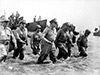 Faillace Oct 20, 1944  Justin Taylan 2005 |
Location Palo is located at an elevation of 19' / 5m on the eastern coast of Leyte in Leyte Province in the Eastern Visayas (Region VIII) in the Visayas (Visayas Islands) in the central Philippines. Also known as Polo. To the north is the Palo River. Palo is located at the intersection of Highway 1 and Highway 2. To the north is Tacloban and to the south is Tanauan and beyond Dulag. To the west is Jaro and beyond Carigara. To the east is Leyte Gulf. Wartime History By October 1944, the Imperial Japanese Army (IJA), 16th Division, 33rd Infantry Regiment (33rd IR) defended the area spanning from Palo to Tacloban as the first line of defense for any amphibious assault on the eastern coast. On October 20, 1944 A-Day, heavily damaged in the pre-invasion Naval bombardment. The U.S. Army landed on Red Beach to the north of Palo. On the northern half landed the 34th Infantry Regiment (34th IR) and advanced to the northwest. On the southern half landed 19th Regiment (19th IR) that advanced south to the Palo River and inland towards Guinhangdan Hill (Hill 522). Palo was the first town on Leyte liberated by the Americans. Red Beach (MacArthur Landing Memorial) Also known as the MacArthur Leyte Landing Memorial National Park, Leyte Landing Memorial Park or MacArthur Park that commemorates the location where General Douglas MacArthur landed at Leyte and thus made good on his promise "I shall return". Bronze statues in a man made pool of water depict the landing. Nearby is a museum with photos, a copy of his speech and even bronzed footprints of the general, when he returned to the Philippines in 1961. Guinhangdan Hill (Hill 522) This feature was designated Hill 522 by the U.S. Army and was an objective during the initial landing. References U.S. Army in World War II The War in the Pacific Leyte: The Return to the Philippines Chapter IV The Return page 52 (33rd IR Palo and Tacloban) U.S. Army in World War II The War in the Pacific Leyte: The Return to the Philippines Chapter V A Day: 20 October 1944 pages 62 (X Corps to seize Palo and Red Beach), 63 (photo), 64 (map), 67 (24th ID Palo), 70 (Hill 522), 72, 73 (map), 78 Contribute
Information Last Updated
|
Map Oct 20, 1944 Map X Corps Oct 20, 1944 Map Fallingrain Map Mapcarta |
| Discussion Forum | Daily Updates | Reviews | Museums | Interviews & Oral Histories |
|