|
|
|
|
| Missing In Action (MIA) | Prisoners Of War (POW) | Unexploded Ordnance (UXO) |
| Chronology | Locations | Aircraft | Ships | Submit Info | How You Can Help | Donate |
|
 USN October 24, 1944 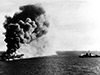 USN January 4, 1945 |
Location The Sulu Sea is located in the southwest Philippines. Borders the South China Sea to the northwest, Palawan to the west and the Sulu Archipelago (Sulu Islands), Celebes Sea to the south and Mindanao to the southeast. To the southwest is Borneo. The Sulu Sea connects to Panay Gulf, Iloilo Strait, Guimaras Strait and Basilan Strait. Includes the Visayas Islands Cuyo Islands, Cagayan Islands and borders Panay Island and western Negros Island in the Western Visayas Region in the Visayas (Visayas Islands) in the central Philippines. Wartime History On October 24, 1944 the Imperial Japanese Navy (IJN) warships of the Southern Force under the command of Vice-Admiral Shōji Nishimura transited the Sulu Sea then entered the Mindanao Sea and Surigao Strait at the start of the Battle of Leyte Gulf. On January 4, 1945 in the Sulu Sea, USS Ommaney Bay (CVE-79) was damaged by a kamikaze P1Y Frances and abandoned and at 7:45pm scuttled by a torpedo. On March 19, 1945 in the Sulu Sea, A-20G Havoc 43-22155 pilot 1st Lt. Ralph M. Jennings (MIA) ditched off northwest Panay Contribute
Information Last Updated
|
Map Mapcarta |
| Discussion Forum | Daily Updates | Reviews | Museums | Interviews & Oral Histories |
|