|
|
|
|
| Missing In Action (MIA) | Prisoners Of War (POW) | Unexploded Ordnance (UXO) |
| Chronology | Locations | Aircraft | Ships | Submit Info | How You Can Help | Donate |
|
 U.S. Army 1944 |
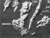
Location Negros Island is the fourth largest island in the Visayas (Visayas Islands) in the central Philippines. Borders the Visayan Sea to the north and Cebu Island to the east. To the west is the Guimaras Strait, Guimaras Island and Panay Island. To the east is Tañon Strait (Tanon Strait) and beyond Cebu Island. Today, Negros Island is divided between two provinces and regions: Negros Occidental Province in the Western Visayas Region (Region VI) and Negros Oriental Province in the Central Visayas Region (Region VII). Wartime History During 1942 the Japanese Army occupied Negros during their occupation of the Philippines and developed the coastal areas of Negros Occidental Province into a major airfield area for the 4th Air Army, 2d Air Division. By late late 1944 occupied by the 18th Army under the commanded by Lt. General Takeshi Kono with 13,500 troops, the largest concentration of soldiers in the Visayas when U.S. forces landed on Leyte on October 20, 1944. The Japanese hoped to stop or delay any further U.S. advances in the Visayas but did not have the strength, supplies, air power or naval support and opted to defend the rugged mountains of northwestern Negros for a protracted battle to delay the Americans. American Landings On March 29, 1945 without pre-invasion bombardment to give the element of surprise, the U.S. Army 40th Infantry Division, plus Filipino guerillas made an amphibious landing on western Negros. Their first objective was the Bago River bridge. A reinforced platoon landed ahead of the main force to prevent the Japanese from blowing this bridge, and allowed the Americans to advance to Bacolod. As the main landing force advanced, they were only stopped by occasional defenses, liberating Bacolod and the coastal areas in a week. On April 7, 1945 the 503rd Parachute Regiment (503rd PIR) landed as reinforcements. After the American landing, Japanese fought tenaciously for six weeks defending in the north of the island, despite heavy air attacks and artillery. This resistance was finally overrun by late April, and remaining Japanese fled to the south with isolated battles until May, and defenses in the north until June 1945, and 6,000 Japanese survived the battle until the end of the war. On April 26, 1945 the U.S. Army, Americal Division made a landing on the southeast coast, and rapidly linked up with elements of the 40th Infantry Division. But, it took a month to neutralize the 1,300 Japanese in this area of the island. Negros Oriental Province includes the southeastern half of the island in the Central Visayas Region. Negros Occidental Province Province includes the northwestern half of Negros, located in the Western Visayas Region. References U.S. Army in World War II - Triumph in the Philippines Chapter XXXI The Central Visayan Islands pages 603 (map), 604-608 (Northern Negros) Contribute
Information Last Updated
|
Map March 1945 Map Fallingrain |
| Discussion Forum | Daily Updates | Reviews | Museums | Interviews & Oral Histories |
|