Location
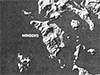
Mindoro Island is located in the Mimaropa Region (Southwestern Tagalog Region, Region IV-B) of the Philippines. Also known as simply Mindoro and the island is the seventh largest in the Philippines. Until 2016 designated Region IV-B. Mindoro is divided into two provinces: the eastern half Oriental Mindoro Province and the western half Occidental Mindoro Province. Borders the Mindoro Strait to the west. To the northeast is Marinduque Island.
Contribute
Information
Do you have photos or additional information to add?
Last Updated
October 10, 2025
|