|
|
|
|
| Missing In Action (MIA) | Prisoners Of War (POW) | Unexploded Ordnance (UXO) |
| Chronology | Locations | Aircraft | Ships | Submit Info | How You Can Help | Donate |
|
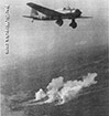 JAAF 1942  US Army January 10, 1942 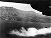 90th BG Feb 16, 1945 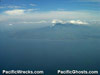 Justin Taylan 2005 |
Location The Bataan Peninsula is located in Bataan Province in the Central Luzon Region (Region III) of Luzon in the Philippines. Borders Manila Bay to the east and the South China Sea to the west. Borders Subic Bay at the northwest and the South China Sea to the west and Manila Bay to the south and east. To the south is the North Channel at the entrance of Manila Bay and beyond Corrigidor Island and Caballo Island. Wartime History The Bataan Peninsula became the American and Filipino defensive line after Japanese landings on Luzon. On December 24, 1941 the evacuation to the Bataan Peninsula begins with General Douglas MacArthur and President Manuel Quezon being evacuated from Manila to Corrigidor. American and Filipino units withdrew to Bataan to continue their defense for months. On January 10, 1942 at dawn General Douglas MacArthur and chief of staff, Maj. Gen. Richard K. Sutherland plus their senior staff travel by PT Boat from Corregidor Island to Mariveles on the Bataan Peninsula. Next, they drove up the East Road to General George E. Parker's headquarters where they talked with II Corps officers and inspected positions in that sector. Moving west across the Pilar-Bagac road MacArthur met General Jonathan M. Wainwright and inspected I Corps installations. When Wainwright offered to show MacArthur their 155mm howitzers, MacArthur replied, "I don't want to see them. I want to hear them." That same day, a Japanese aircraft dropped a message behind U.S. lines that demanded their surrender. This eight hour inspection was Macarthur's only visit to the area. On April 8, 1942 the Bataan peninsula was surrendered to the Japanese by Major General Edward P. King, ending the defense of Bataan. Bataan Death March After the surrender, the Imperial Japanese Army forced the roughly 78,000 American and Filipino Prisoners Of War (POWs) on a march roughly 100+ kilometers without food, water or medical supplies that was dubbed the "Bataan Death March" from where they surrendered on the Bataan Peninsula northward to San Fernando where they were loaded onto crowded rail road cars and transported to Camp O'Donnell (Capas) with the officers detained at Cabanatuan POW Camp. Afterwards, the Bataan Province was occupied by Japanese forces during their occupation of the Philippines. Starting in the middle of January 1945 attacked by American bombers and fighters to neutralize defenses and prevent the Japanese from anchoring a defense in the Bataan Peninsula. American missions against Bataan Peninsula January 18, 1945–February 20, 1945 On January 29, 1945 the U.S. Army had advanced to the north of the Bataan Peninsula. On February 12, 1945 the 152nd Infantry advancing eastward from Olongapo and the 149th Infantry advancing westward from Balsic linked up, isolating the Japanese forces defending the Bataan Peninsula. During February 1945, the U.S. Army advanced down the eastern coast liberating Orani then advancing southward and westward with Bagac liberated on February 21, 1945 liberating the Bataan Peninsula. Bataan Peninsula Locations Balsic located on the northern Bataan Peninsula. Bulate located on the northern Bataan Peninsula. Culo located on the northern Bataan Peninsula. Orani located at the northeast tip of Bataan Peninsula and Orani Airfield. Abucay located on the east of the Bataan Peninsula site of the Abucay-Morong Line during January 1942. Pilar located on the east of the Bataan Peninsula includes Pilar Airfield and Mt. Samat National Shrine. Balanga located on eastern Bataan Peninsula inland from Pilar site of General Homma headquarters. Orion located on the east of the Bataan Peninsula. Limay located on the east of the Bataan Peninsula site of U.S. Army Major General King surrender site. Lucanin (Lokanin) located on the southeast coast of the Bataan Peninsula includes Bataan Airfield (Limay). Lamao located on the southeast of Bataan Peninsula to the south of Cabcaben. Cabcaben located at the southern tip of the Bataan Peninsula, Cabcaben Airfield. Mariveles located at the southern tip of the Bataan Peninsula, Mariveles Airfield and Wainright surrender site. Mariveles Harbor borders Mariveles at the southern tip of the Bataan Peninsula. Sisiman Bay (Sisiman Cove) east of Mariveles Harbor on the southern tip of the Bataan Peninsula. Mount Mariveles (Mariveles Mountain) located in the Cogon Tarak Ridge on the Bataan Peninsula. Bagac located on the western coast coast of the Bataan Peninsula. Moron located on the western coast of the Bataan Peninsula. Mayagao Point located on the west coast of the Bataan Peninsula. Quinauan Point located on the southern coast of the Bataan Peninsula. Longoskawayan Point (Longos Kawayan Point) located on the southern coast of the Bataan Peninsula. Bataan Peninsula Airfields Orani Airfield located at Orani used during the defense of Bataan disused today. Pilar Airfield located at Pilar used during the defense of Bataan disused today. Bataan Airfield (Limay) located near Lucanin (Lokanin) used during the defense of Bataan disused today. Cabcaben Airfield located near Cabcaben used during the defense of Bataan disused today. Mariveles Airfield located at Mariveles used during the defense of Bataan disused today. Mariveles Seaplane Base located at Mariveles using Mariveles Harbor disused today. References U.S. Army in World War II - The Fall of the Philippines Chapter XII: Holding the Road to Bataan pages 203-215 U.S. Army in World War II - The Fall of the Philippines Chapter XIII: Into Bataan pages 216-231 U.S. Army in World War II - The Fall of the Philippines Chapter XIV: The End of an Era pages 238, 242, footnotes 4, 10, 26, 28 U.S. Army in World War II - The Fall of the Philippines Chapter XV: Setting the Stage pages 245-264 U.S. Army in World War II - The Fall of the Philippines Chapter XVI: The First Battle of Bataan pages 265-295 U.S. Army in World War II - Triumph in the Philippines Chapter XVII: Back to Bataan pages 309-334 Contribute Information Do you have photos or additional information to add? Last Updated January 29, 2026 |
Map Feb 12-21, 1945 Map Fallingrain Photo Archive |
| Discussion Forum | Daily Updates | Reviews | Museums | Interviews & Oral Histories |
|