|
|
|
|
| Missing In Action (MIA) | Prisoners Of War (POW) | Unexploded Ordnance (UXO) |
| Chronology | Locations | Aircraft | Ships | Submit Info | How You Can Help | Donate |
|
 IJA May 5, 1942 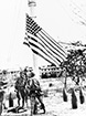 IJA May 6, 1942  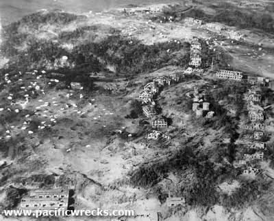 USAAF Feb 16, 1945 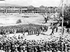 U.S. Army March 2, 1945 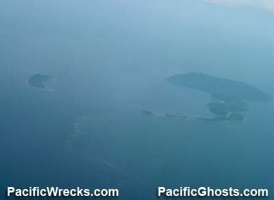 Justin Taylan 2005 |
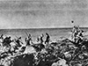
Location Corregidor Island is located in the North Channel of Manila Bay off Luzon in the Philippines. Also know as simply "Corregidor", "The Rock" or "Fort Mills". To the southeast is Caballo Island (Fort Hughes) and El Fraile (Fort Drum). To the north is North Channel and beyond the southern edge of the Bataan Peninsula on Luzon. To the south is the South Channel and beyond Cavite Province on Luzon. To the east is Manila. Beyond to the west is the South China Sea. Construction The U.S. Army Corps of Engineers developed Corregidor Island into Fort Mills to defend Manila Bay and Manila. The island was developed with extensive military fortifications including gun batteries, mortar positions, anti-aircraft guns and military infrastructure plus Malinta Tunnel (Malinta Hill) and Kindley Field (Landing Strip, Corregidor Airport) to defend the island. Wartime History On December 26, 1941 U.S. Navy (USN) Naval Defense forces plus the U.S. Marine Corps (USMC) battalion from Cavite move to Corregidor. After the Japanese Army occupied Bataan and Cavite, their artillery begins bombarding Corregidor while Japanese aircraft bomb and strafe to soften up the defenses. Japanese missions against Corregidor January 4, 1942–May 6, 1942 On March 11, 1942 at 7:30pm at north dock on General Douglas MacArthur and his family plus other senior staff members were evacuated by order of U.S. President F. D. Roosevelt aboard PT-32, PT-34, PT-35 and PT-41. The Patrol Boats sped southward evading Japanese forces and disembarked the group on Mindanao and they were flown from Del Monte Airfield aboard B-17 Flying Fortresses to Darwin in Australia. On May 5, 1942 a force of 2,0000 Japanese Army soldiers from the 4th Division, 61st Infantry under the command of Col. Gempachi Sato embarked aboard barge from the 1st Sea Operation Unit at Lamao and after dark bound for the north coast of Corregidor and planned to land between Infantry Point and Cavalry Point. Due to the tide running eastward caused the landing craft to drift 1,000 yards to the east before they landed to the west of North Point with boat landing at different times spread over a distance. As a result, the 61st Infantry 1st Battalion and 2nd Battalion landing at the wrong beaches as they landed at 11:30pm. Ashore, the defenders targeted the landing craft with a pair of 75mm guns and 37mm guns east of North Point with a few remaining search lights spotting. As the moon rose, defensive fire was added by the last 12" mortar at Battery Way plus 12" gunfire from Batttery Craighill at Fort Hughes on Caballo Island. Although the Japanese suffered heavy casualties with only 800 men reaching the shore, they established a beachhead after combat with Company A, 4th Marines near North Point. On May 6, 1942 by 1:00am the 1st Battalion captured Monkey Point on the south shore and Battery Denver (Denver Hill) and cut the island in half and repelled several counterattacks. Lacking food and ammunition, Lt. General Jonathan M. Wainwright decided to surrender the island at noon to minimize casualties as further resistance was hopeless. During the Japanese occupation of Corregidor, only one Japanese Army reinforced company of approximately 300 men defended the island. The Japanese used approximately 500 Prisoners Of War (POW) to repair installations, perform cleanup and collect scrap for shipment to Japan. The prisoners remained on the island until shortly before the 1945 liberation. As American forces approached, approximately 6,000 Japanese mostly Navy troops occupied the island. During 1945, extensive American bombing missions, U.S. Navy (USN) bombardment and mine clearing operation proceeded the liberation of Corregidor. American missions against Corregidor January 23, 1945–March 1, 1945 On February 16, 1945 the U.S. Army assault on Corregidor was a simultaneous operation that utilized both paratroopers and a simultaneous amphibious landing to assault the island. C-47 Dakotas from the 317th TCG dropped the U.S. Army 503rd Parachute Regiment (503rd PIR) and landed on the center of Corregidor at Topside at 8:33am. Meanwhile, an amphibious landing was made by the U.S. Army 24th Infantry Division, 34th Infantry Regiment under the command of Col. Aubrey S. "Red" Newman landed at between Cavalry Point and Infantry Point on the north coast and another landing at San Jose Point on the eastern edge at Black Beach to capture Malinta Hill. The Japanese defended from caves, and launched banzai charges. On February 21, 1945 they set off demolition charges blowing up Malinta Hill. On February 25, 1945 the 151st Infantry Regiment, 2nd Battalion replaces the 34th Infantry Regiment, 3rd Battalion. On February 26, 1945 shortly after 11:00am, the remaining Japanese on Corregidor made a final suicidal effort by detonating the underground arsenal at Monkey Point causing a huge explosion that erased the small knoll leaving only a crater. The explosion killed roughly 200 Japanese defenders plus 50 Americans 50 killed and 150 wounded with injuries as far away as mile, knocked an M4 Sherman tank 50 yards killing all but one of the crew and off shore debris hit a destroyer 2,000 yards away. By 4:00pm the 503rd PIR reached the eastern tip of the island. Although most of the fighting had ended, mopping up continued against isolated Japanese mostly hiding in caves at the waterline. On March 2, 1945 Corregidor was officially deemed secure. At the flag pole, the U.S. flag was raised on the old Corregidor flagpole while soldiers from "Rock Force" stood at attention with General Douglas MacArthur, General Hall (Commanding Officer "Rock Force) and Lt. Colonel Jones (Commanding Officer, 503rd PIR RCT). After the U.S. flag was raised, Lt. Col Jones stepped forward, saluted and reported to MacArthur: "Sir, I present to you Fortress Corregidor." At the ceremony, MacArthur awarded Jones the Distinguished Service Cross (DSC) and stated: "I see the old flagpole still stands. Have your troops hoist the colors to its peak, and let no enemy ever haul them down." The battle to liberate Corregidor spanned twelve days. The Americans suffered 210 Killed In Action (KIA), 5 Missing In Action (MIA) and 450 Wounded In Action (WIA) and 340 injured. Nearly all the Japanese defenders were killed with at least 4,500 killed and 20 captured that became Prisoners Of War (POWs). Roughly 200 Japanese were killed attempting to swim away and 500 more likely died sealed into caves and tunnels. Today Corregidor is a protected Philippines National Park, A small population lives on the island, to maintain the grounds and guide tourists. Most people choose the short day trip by fast catamaran from Manila, which includes a guided bus tour around some of the more significant sites. For the more serious visitor, there is a nice hotel, and our stays have been up to ten days, much to the amazement of the locals. Battery Way A battery of four mortars, capable of firing in any direction. The last of the four mortars was still firing when the Japanese landed, and Allied forces removed its breech block prior to capture. Today, it is one of the main tourist attractions on Corregidor Island tour. Battery Grubbs Located in the west central inland part of the Corregidor. The battery faces a northwesterly direction, primarily to cover the approached to the North Channel, but was capable of covering the entire channel. Battery Geary A mortar battery built into a hollow on the southern coast of Corregidor. Hit by a a 240mm round penetrated the center magazine, detonating a massive explosion of 40 tons of explosives that utterly destroyed the battery, leaving a large crater where the magazine formerly was located. Battery Crockett A battery of four mortars, capable of firing in any direction. The last of the four mortars was still firing when the Japanese landed, and Allied forces removed its breech block prior to capture. Battery Smith Battery Smith was a long range (26 miles) flat trajectory 12" gun. There were two of these weapons curiously exposed like this, the other being Battery Hearn. Perhaps they didn't build a parapet so as to allow depression of the guns bordering the South China Sea. Each could traverse a full 360 degrees. Battery Hearn Battery Hearn was a long range (26 miles) flat trajectory 12" gun bordering the South China Sea. During the defense of Corregidor by the Americans, this gun was used to fire at Japanese forces on Bataan, but only AP shells were available causing limited damage. Battery Ramsay Located near the the old YMCA building. Built by the U.S. Army prewar to emplace three 6" guns. During 1944, the magazine of this battery was hit by an American bomb causing an enormous explosion when the magazine was hit and destroyed the battery and caused a large crater and caused one of the 6" gun mounts to be thrown onto its side. Battery Wheeler This battery was built between 1904-1919 facing towards the southwest of Corregidor Island that could also lay fire to the northwest to Mariveles on the Bataan Peninsula. Battery Cheney Located on the southwest corner of the island bordering the South China Sea. This battery had two 12" guns on M1901 disappearing gun carriages. Battery Denver (Denver Hill) Located on a ridge between Infantry Point and Cavalry Point. On May 6, 1942 at 1:30am the Japanese captured this location and established a north to south line across the island and repelled three counterattacks. Japanese Tunnel Carved by the Japanese, along the tracks at Battery Rock Point and Middle side. Mile Long Barracks Nicknamed 'Mile Long Barracks' it was said to be the longest barracks in the world (although not actually a mile long). Heavily damaged during the capture and liberation of the island, the ruins are still standing today. Flagpole (The Old Corregidor Flagpole) The original flag pole remains on Corregidor. On March 2 1945 after the twelve day battle to liberate Corregidor, the U.S. flag was raised on this flag pole while soldiers from "Rock Force" stood at attention with General Douglas MacArthur, General Hall (Commanding Officer "Rock Force) and Lt. Colonel Jones (Commanding Officer, 503rd PIR RCT). After the U.S. flag was raised, Lt. Col Jones stepped forward, saluted and reported to MacArthur: "Sir, I present to you Fortress Corregidor." At the ceremony, MacArthur stated: "I see the old flagpole still stands. Have your troops hoist the colors to its peak, and let no enemy ever haul them down." Topside Barracks (Topside) Prewar barracks building. Malinta Tunnel (Malinta Hill) Located roughly in the center of the island. This massive underground headquarters and supplies storage area for the USAFFE. Kindley Field (Landing Strip, Corregidor Airport) Runway on the eastern end of Corregidor. Battery Kysor Located on the north side of the island, to the west of Kindley Field. Filipino Women Statue To the SW of Battery Kysor. Medical Marker / General Wainwright Memorial Located on the south coast of the island, near the south dock. North Dock Landing point on the north side of Corregidor. On March 11, 1942 at 7:30pm PT-41 arrives at north dock and embarks General Douglas MacArthur, his family and senior staff then departs on a 560 mile voyage to Mindanao. South Dock Landing point on the south side of Corregidor in roughly in the center of the island. Battery Maxwell Keyes Located to the SW of Kindley Field, on the south side of the island. Naval Radio Intercept Tunnel Located to the east of Battery Maxwell Keyes. Filipino Heroes Memorial / President Osmena Statue Located to the SE of Battery Kysor. Lighthouse Located on the island. References U.S. Army in World War II The Fall of the Philippines Chapter XXVII The Siege of Corregidor pages 471-497 U.S. Army in World War II - The Fall of the Philippines Chapter XXIX: Japanese Plans and American Defenses pages 520-535 U.S. Army in World War II - The Fall of the Philippines Chapter XXX: The Last Twenty-Seven Days pages 536-551 U.S. Army in World War II The Fall of the Philippines Chapter XXXI: The Fall of Corregidor pages 552-561 U.S. Army in World War II The Fall of the Philippines Chapter XXXII: The End of Resistance pages 562-584 U.S. Army in World War II Triumph in the Philippines Chapter XVIII Corregidor pages 335-350 Corregidor.org information and historic resources The 25 Best World War II Sites Pacific Theater (2002) pages 10-17 Contribute
Information Last Updated
|
Map May 5-6, 1942 Map Feb 16, 1945 Map Fallingrain Photo Archive |
| Discussion Forum | Daily Updates | Reviews | Museums | Interviews & Oral Histories |
|