 |
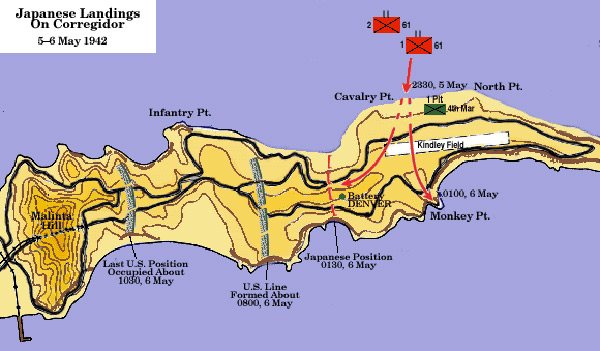
Map of Japanese landings and U.S. lines on Corregidor Island
The map includes Corregidor Island locations including Infantry Point, Cavalry Point, North Point, Kindley Field and Monkey Point. The red lines indicates the Japanese Army 61st Infantry, 1st Battalion and 2nd Battalion lines: May 5, 1942 at 2330 landing between Cavalry Point and North Point. On May 6, 1942 at 100 capture of Monkey Point and the Japanese position atop Battery Denver (Denver Hill) at 130.
The blue lines indicate
U.S. line formed May 6, 1942 at 800 and last U.S. position occupied about 1030.
Credit: U.S. Army Chapter XXXI: The Fall of Corregidor page 554 Date: May 5–6, 1942
B&W
High Resolution Version
Acquire This Image |
Contribute Information
Do you have photos or additional information?
Previous Page
|
|