|
|
|
|
| Missing In Action (MIA) | Prisoners Of War (POW) | Unexploded Ordnance (UXO) |
| Chronology | Locations | Aircraft | Ships | Submit Info | How You Can Help | Donate |
|
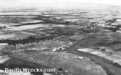 Prewar 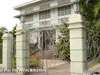 Lazatin 2002 |
Location Lat 14° 58' 60N Long 120° 31' 60E San Fernando is located on the San Fernando River in Pampanga Province on Luzon in the Philippines. Also known as "Santo Rosario".To the northwest is Angeles and beyond Clark Field. To the southeast is the Pampanga River and Calumpit and beyond Manila Bay and Manila. The Manila Rail Road (Manila R. R.) and Route 3 road runs from the southeast to northwest via San Fernando. Wartime History On May 6, 1942 after the surrender of American and Filipino forces on the Bataan Peninsula, the Japanese forced the Prisoners Of War (POW) to walk from Mariveles northward to San Fernando on the "Bataan Death March" then were loaded onto rail road cars and transported to Cape O'Donnell (Capas). On January 28, 1945 liberated by U.S. Army 37th Infantry Division, 37th Rcn Tr patrol and elements of 148th Infantry Regiment. San Fernando Airfield Prewar American airfield, used by Japanese as an emergency strip. Lazatin House This prewar house was owned by Serafin Lazatin, owner of PASUDECO (Pampanga Sugar Development Company) and the owner of many acres a lot of sugar cane land. During 1942 this home was used as the personal residence of Japanese Army General Masaharu Homma. During the occupation, Serafin Lazatin was murdered by Hukbalahap "Huks" (Communist Rebels). Today, the home is still owned by the Lazatin family and has dinner there ever Sunday together at the house. [Dining room interior view] Contribute
Information Last Updated
|
Map Feb 1, 1945 Map Fallingrain |
| Discussion Forum | Daily Updates | Reviews | Museums | Interviews & Oral Histories |
|