|
|
|
|
| Missing In Action (MIA) | Prisoners Of War (POW) | Unexploded Ordnance (UXO) |
| Chronology | Locations | Aircraft | Ships | Submit Info | How You Can Help | Donate |
|
 USN c1944 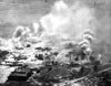 USN June 19, 1944  USN 1945  Marek 2004 |
Location Wartime History Tanapag Harbor Seaplane Base Daihatsu Landing Craft Shohan
Maru (Chinsen Maru) Contribute
Information Last Updated
|
Feb 23, 1944 April 4, 1944 Photo Archive |
| Discussion Forum | Daily Updates | Reviews | Museums | Interviews & Oral Histories |
|