|
|
|
|
| Missing In Action (MIA) | Prisoners Of War (POW) | Unexploded Ordnance (UXO) |
| Chronology | Locations | Aircraft | Ships | Submit Info | How You Can Help | Donate |
|
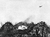 USMC September 1944 |
Location Umurbrogol is a massif feature comprised of hills, canyons and ridges to the northeast of Peleliu Airfield on Peleliu Island in Peleliu State in Palau (Republic of Palau, (Belau, Pelew). Also known as Umurbrogol Mountain. During the Battle of Peleliu southern slopes were nicknamed "Bloody Nose Ridge" and the northern Japanese defenses were known as the "Umurbrogol Pocket". Umurbrogol included Hill 100 (Higashiyama, Pope’s Ridge) and Hill 120, Hill 140, Hill 300, Five Sisters, China Wall, Death Valley, Five Brothers, Wildcat Bowl, Walt Ridge, Hill 140, Ridge 3, Boyd Ridge, Ridge 120, Unnamed Ridge, Wattie Ridge, Baldy Ridge, Baldy and Knobs. Bordered "West Road" to the west and "East Road" to the east. This location was the site of the most costly fighting during the Peleliu campaign. Wartime History During September 1944, the Japanese defended this feature. From their positions in and on the hills, the Japanese were able to interdict American movements along the East Road or West Road. The southern slopes overlooked the landing beaches and Peleliu Airfield. The southern slopes of Umurbrogol were attacked by the 1st Marine Division under Puller with 2/7 attached. By September 19, 1944 the southern slopes were secured but the Japanese were still able to harass the Americans. On September 20, 1944 the 7th Marines took over the offensive and between September 21-29, 1944 attempts were to advance from the south to north. Despite American artillery, tank and air support, enemy positions inside the hills and canyons were untouched and able to fire down on advancing Marines. The Marines were determined to break the defense but their offensive devolved into a long siege to reduce the defensive position. Attacked by U.S. Marines including the 7th Marines and U.S. Army 81st Division until November 27, 1944 (D plus 73) when the defenders were finally neutralized. References Marines in World War II Commemorative Series "Bloody Beaches: The Marines at Peleliu" pages 3, 7, 12, 19, 20-26, 28-29, 35-36, 42, 44 History of the U.S. Marine Corps Operations in World War II - Western Pacific Operations Chapter 6 Securing the North: 23-30 September pages 189 "From their positions in and on the hills, the Japanese were able to interdict all movement along the East and West Roads, which generally paralleled the island coastlines north of the [Peleliu] airfield." Contribute
Information Last Updated
|
Map Sept 16-23, 1944 |
| Discussion Forum | Daily Updates | Reviews | Museums | Interviews & Oral Histories |
|