|
|
|
|
| Missing In Action (MIA) | Prisoners Of War (POW) | Unexploded Ordnance (UXO) |
| Chronology | Locations | Aircraft | Ships | Submit Info | How You Can Help | Donate |
|
|
|
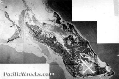
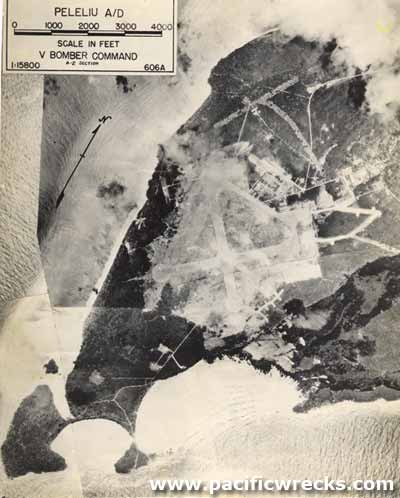
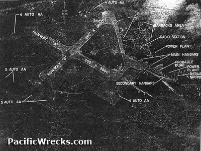
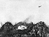
Location Peleliu Island is located in Peleliu State the center of Palau (Republic of Palau, Belau, Pelew). Also spelled Beliliou in the local language. The island encompasses five square miles in land area. To the north is Ngesebus Island and Kongauru Island and to the southwest is Angaur Island. Prewar Prior to World War I, Peleliu was a German colony. After World War I, the League of Nations mandated Palau to Japan administered by the Imperial Japanese Navy (IJN). During March 1922 Palau became been the headquarters of the Japanese South Seas Colonial Administration with a civilian administration. Contrary to the League of Nations mandate, the Japanese military developed Palau into a military base. Wartime History By September 1944, roughly 6,000 Japanese defended Peleliu. Starting in June 1944, U.S. Army Air Force (USAAF) B-24 Liberators and U.S. Navy (USN) carrier aircraft conducted bombing missions against Peleliu prior to the amphibious landings then flew close air support missions until the conclusion of the battle. Contrary to what American planners believed, Peleliu was heavily fortified. American and Japanese missions against Peleliu June 9, 1944 - November 29, 1944 On September 15, 1944 the U.S. Marine Corps (USMC), 1st Marine Division (1st MARDIV) made an amphibious landing on the southwest of Peleliu. On the first day, a portion of Peleliu Airfield was captured and by D+2 was liberated and repaired for use by American aircraft. For a month, Japanese defenses on Umurbrogol Ridge (Battle of Bloody Nose Ridge) hauled the Marines advance. The two month battle became one of the bloodiest battles of the Pacific War with over 20,000 casualties. On October 13, 1944 organized Japanese resistance on the island ended, although some groups of Japanese soldiers continued to hold out for the remainder of the Pacific War and continued to conduct harassing attacks. Orin Whitman 1st Marine Division recalls: "The Marines called for help, [on Peleliu] on 23rd and [from Angaur] we relieved some of the Marines they were shot up bad, Major Ray Davis lost 71% of his battalion any one who survived Peleliu should have some kind of medal, It was tough there. Also went to Leyte PI but it was nothing like Peleliu. Went on to Japan and was home 28 of Feb. 1946. Went back to Peleliu in September 1999 for the 55th anniversary. The Island didn't look the same but lot of the pill boxes, bunkers, air strip, guns and gun emplacements were just as we left them, Peleliu was one hell of a place in 44, no way I can describe it." Postwar After the Pacific War, a small contingent of U.S. personnel remained on Peleliu Island. By early 1947, only 150 U.S. Marines were stationed on the island with 35 dependents. During the end of March 1947, a group of 33 Japanese soldiers led by Lt. Ei Yamaguchi attacked a Marine patrol with hand grenades. Luckily, none of the Americans were injured but reinforcements were called in to hunt down the holdouts. With a Japanese Admiral sent to convince the group the war was over, the holdout emerged in two groups during late April 1947 and their Yamaguchi turned over his sword and battle flag to the Americans. In 1994, he returned for the 50th anniversary commemorations. On July 1, 1947 the Marine garrison on Peleliu was disbanded with the last twenty-one Marines (20 enlisted and one officer) were transfered to Koror. Today Peleliu is sparsely inhabited. Even to the present day, unexploded ordnance (UXO) continues to be found and detonated. The island is rarely visited by outsiders. During 1994 on the 50th anniversary, some USMC veterans returned with family members and others interested in the battle. White Beach / Bloody Beach On September 15, 1944 "White Beach" was the site of the the U.S. Marine Corps 1st Marine Division (1st Mar Div) landings on Peleliu. There is a huge blockhouse inland of White Beach that has been renovated into the new Peleliu museum. During the battle, the blockhouse was heavily fortified and delayed the advance of the 1st Marines. Supporting arms failed to neutralize the position and it finally took the 14" guns of a battleship to destroy the fortification! Maj. Ray Davis then moved his CP group near the structure and the blockhouse was used as the 1st Battalion aid station. Orange Beach Located on the south-west corner of the island. On September 15, 1944 the USMC 5th and 7th Marines landed at this beach. Today, wreckage remains on shore. Peleliu Airfield Built by the Japanese, captured by American forces in September 1944. Umurbrogol (Bloody Nose Ridge) Umurbrogol is a massif hill feature to the northeast of Peleliu Airfield parallel to the western coast of Peleliu Island. Also known as simply Umurbrogol, Umurbrogol Mountain, Umurbrogol Mt., Umurbrogol Pocket. Nicknamed Bloody Nose Ridge by the U.S. Marines during the Battle of Peleliu. Hill 100 (Pope’s Ridge, Walt's Ridge) Ridge located to the north of Peleliu Airfield TBM-1C Avenger Bureau Number 16956 Pilot Baxter crashed September 13, 1944 Japanese Memorial Tori gate and park area US Army 81st Infantry Memorial Simple memorial of two stone pillars and a white cross M4 Sherman Tank Disabled by a mine flipped on its side LVT(A)-1 Landing Vehicle Tracked War Museum Bunkers and
Japanese Headquarters Japanese
Supply Ship A6M Zero A6M Zero Contribute
Information Last Updated
|
Map 1944 Map Assault Sept 15-23, 1944 Map 2nd Phase Sept 16-23, 1944 Photo Archive |
| Discussion Forum | Daily Updates | Reviews | Museums | Interviews & Oral Histories |
|