Missing In Action (MIA)
Prisoners Of War (POW)
Unexploded Ordnance (UXO)
Chronology
Locations
Aircraft
Ships
Submit Info
How You Can Help
Donate
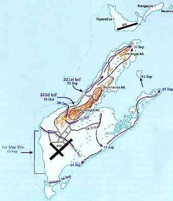
Map of
Peleliu Island
in southern
Palau (Belau)
Indicated is
Peleliu Island
and
Peleliu Airfield
, Sniper Road and
Umurbrogol Ridge (Bloody Nose Ridge)
. To the north is
Ngesebus Island (Ingesebus)
and
Ngesebus Airfield (Ingesebus)
. The lines indiate the U.S. Marine Corps (USMC) 1st Marine Division advance during September 1944 with dates indicated at each front line. To the southwest is
Un-named Island (Island X)
.
Credit: USMC Date: September 1944
Map
High Resolution Version
Acquire This Image
|
Contribute Information
Do you have photos or additional information?
Previous Page
Discussion Forum
Daily Updates
Reviews
Museums
Interviews & Oral Histories
Pacific Wrecks Inc.
All rights reserved.