|
|
|
|
| Missing In Action (MIA) | Prisoners Of War (POW) | Unexploded Ordnance (UXO) |
| Chronology | Locations | Aircraft | Ships | Submit Info | How You Can Help | Donate |
|
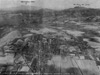 U.S. Army Feb. 18 1935 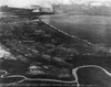 U.S. Army August 12, 1937 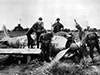 AP January 31, 1945 |
Location Lat 14° 4' 20N Long 120° 37' 60E Nasugbu is located at an elevation of 42' / 12m above sea level on the western coast of Batangas Province on Luzon in the Philippines. Located south of the entrance to Manila Bay. To the south is the Lian River and San Diego Point. To the north is Wawa and the Wawa River. Prewar, a pier is located at Wawa at the mouth of the Wawa River that was damaged during a 1938 typhoon. An extensive narrow gauge rail road was built in the area for transporting sugar cane. Route 413 runs from Nasugbu connecting to Manila. Wartime History During early 1942, the pier at Wawa was demolished by retreating Allied forces. During January 1942, occupied by the Japanese Army. On January 31, 1945 at dawn after a Naval shore bombardment and air support, U.S. Navy Task Group 78.2 (TG 78.2) under Rear Admiral William M. Fechteler lands the U.S. Army, 11th Airborne Division, 188th Glider Infantry Regiment at Nasugbu and encounters only light resistence and liberates the town then advances inland up Highway 17 and across the Lian River and reaches the Palico River. At 10:30am the 187th Glider Infantry Regiment lands. Nasugbu Airfield Built prewar as an emergency landing ground and occupied by the Japanese Contribute
Information Last Updated
|
Map 1944 Map Fallingrain |
| Discussion Forum | Daily Updates | Reviews | Museums | Interviews & Oral Histories |
|