|
|
|
|
| Missing In Action (MIA) | Prisoners Of War (POW) | Unexploded Ordnance (UXO) |
| Chronology | Locations | Aircraft | Ships | Submit Info | How You Can Help | Donate |
|
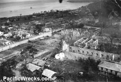 5th AF 1945 |
Location Lat 16° 37' 7N Long 120° 19' 10E San Fernando is located at an elevation of 180' / 54m and is the provincial capital of La Union Province on the west coast of Luzon in the Philippines. Borders San Fernando Harbor and beyond Lingayen Gulf. Wartime History In early December 1941 occupied by the Japanese Army. During the Pacific War, San Fernando was an important shipping point for the Japanese. Starting in the middle of December 1944, targeted by American fighters and bombers until liberated. In early 1945, became known as Base M (San Fernando) as a staging area to support the U.S. Army liberatation of Luzon. American missions against San Fernando December 15, 1944–1945 Base M (San Fernando) US Army letter Base designation. After liberation, the area was developed into a major American staging base and camp area. Monument to the Unknown Soldier A WWII Monument in the center of town, dedicated to the unknown soldier funded by the city's Lion's Club. San Fernando Airfield Used by Japanese as a seaplane base and Americans as airfield after liberation American M10A1E Tank Dump At the end of the war at least five U.S. Army M10A1E tanks were dumped in deep water on Fagg Reef, off San Fernando. M10A1E (No. 1) and M10A1E (No. 2) both at 41m (140'). A third, M10A1E (No. 3) is upside down, and a fourth M10A1E (No. 4) is located to the east of the main dump area. A fifth tank M10A1E (No. 5) is in deep water (200'), along with other dumped wartime debris. Shipwrecks Two Japanese shipwrecks were discovered in 1984 off Barangay Sinaite (La Union). Bauang River Wreck WWII cargo ship 90' in mouth of Bauang River. This ship was largely salvaged or demolished postwar, only small pieces remain. Contribute
Information Last Updated
|
Map December 22-24, 1941 Map Fallingrain Map Mapcarta |
| Discussion Forum | Daily Updates | Reviews | Museums | Interviews & Oral Histories |
|