|
|
|
|
| Missing In Action (MIA) | Prisoners Of War (POW) | Unexploded Ordnance (UXO) |
| Chronology | Locations | Aircraft | Ships | Submit Info | How You Can Help | Donate |
|
 5th AF c1943 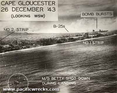 5th AF Dec 26, 1943 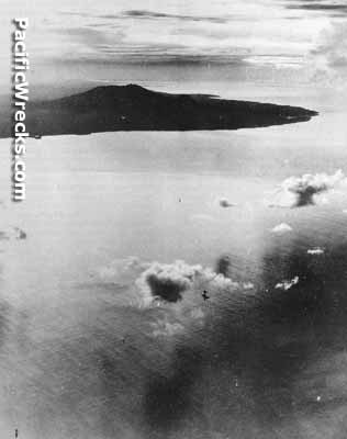 380th BG Dec 26, 1943 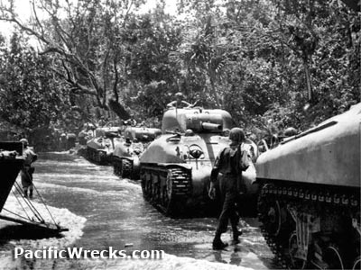 USMC December 1943 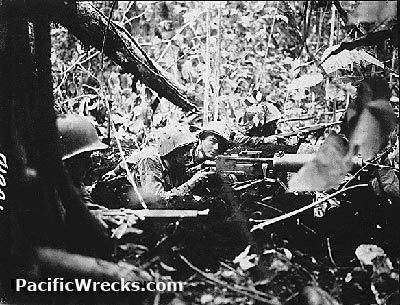 USMC January 1, 1944 |
Location Lat 5° 31' 0S Long 148° 31' 0E Cape Gloucester is located at sea level on the north coast of western New Britain. Known to the Japanese as Tuluvu. Prewar and during the Pacific War part of the New Britain District in the Territory of New Guinea. Today located in West New Britain Province of Papua New Guinea (PNG). Wartime History On December 17, 1942 at dawn under cloud cover, Tachikaze and Patrol Boat No. 39 land a force of 350 Japanese personnel at Cape Gloucester. The detachment under the overall command of Major Kiyomitsu Mukai, the construction battalion commander, rapidly secured Cape Gloucester Airfield (No 1 Strip) and established a 40 km beachhead area. Starting in late December 1942, Cape Gloucester was targeted by Allied planes conducting reconnaissance and strike missions ahead of the U.S. landing then until late January 1944 when the area was secured. Allied missions against Cape Gloucester December 23, 1942–January 29, 1944 The Americans wanted to capture Cape Gloucester Airfield to secure an airfield closer to Rabaul. On December 15, the U.S. Army's 112th Cavalry made an assault on the Arawe to the southeast of Cape Gloucester as a diversionary attack to distract the Japanese from the main Marine landing at Cape Gloucester. On December 26, 1943 at 7:46am after a brief naval bombardment and aerial smoke screen, U.S. Marines from the 1st Marine Division (1st MARDIV) commanded by Major General William H. Rupertus land at Yellow Beach 1 and Yellow 2 and Green Beach at Cape Gloucester. Ashore, the Marines faced swampy terrain and thick jungle, but met only rear-echelon Japanese troops. Some criticized the landing unnecessary, as the Allies already had total control of the Huon Peninsula of New Guinea. The Marines landed with the M1 Garand rifle and were supported by M4A1 Sherman medium tanks and above Piper L-4 Grasshopper and Stinson L-5 Sentinel were used for artillery spotting, supply drops and message relay. Once the Cape Gloucester was secured, the Marines advanced eastward along the north coast towards the Willaumez Peninsula. Once the area was secured, they were relived by the U.S. Army 40th Division commanded by Major General Rapp Brush then later by the Australian Army 5th Division. Cape Gloucester Airfield (Tuluvu) Located at the northern most tip of Cape Gloucester. Its construction was begun by the Australians, finished by the Japanese and improved by the Americans after liberation. Mikazuki (Mikatsuki) Ran aground July 27, 1943 off Cape Gloucester, sunk by Army aircraft July 28, 1943 B-25D "Here's Howe" Serial Number 41-30279 Hit by US Navy anti-aircraft fire and crashed. B-25D "Crabb 2nd" Serial Number 41-30517 Hit by US Navy anti-aircraft fire ditched and crew made it ashore in raft USS Brownson (DD-518) Sunk December 26, 1943 by Val dive bombers off Cape Gloucester off Yellow Beach Government Station (Yellow Beach 1 & 2) Located to the east of Cape Gloucester Airfield. Yellow Beach 1 (Webber) was the site of the initial landing at 7:46am. The landing at Yellow Beach 2 (Williams) followed at 7:48am. Remains of some landing craft are present on the beach. While moving inland into a large swamp, Captain Joseph A. Terzi commander of Company K was killed by fire from a camouflaged bunker and posthumously awarded a Navy Cross for valor leading the attack. Today, between the strip and the government station are abandoned American Armored Personnel Carriers (APC). Silimati Point Point located to the south-east of the Yellow Beach landing areas, including Target Hill, Suicide Creek and Hill 150, Hill 660 and Aogiri Ridge. Target Hill High ground located to the left flank of the Yellow beaches, near Silimati Point. Captured December 26, 1943 by assault battalions of the 7th Marines. Counter attacked by Col. Kenshiro Katayama 141st Infantry. Japanese believed only 2,500 Marines were ashore (10% of the actual number). Scaling up the hill on the night of January 2-3, 1944 they attacked failing to probe the line first and were repulsed. Green Beach Site of diversionary landing by 1,500 Marines that landed December 26 at 07:48a but met no opposition. Hampered by weather and unable to find the trail they were supposed to block, they were not attacked until dawn on December 30, one Marine Gunnery Sgt Guiseppe Guilano, Jr. earned the Navy Cross for firing a .30 caliber machine gun from the hip at attackers. The attack left 6 KIA, 17 WIA Marines and 89 KIA and 5 POW Japanese. Blue Beach (Hell's Point) Landing beach three miles to the west of Yellow Beach, closer to the airfield. 1st Marines, 3rd Battalion (Col Hawkins) landed at the flank of the point. Defended by the Japanese with bunkers, it was attacked by Marines and Sherman tanks. 9 KIA 36 WIA Marines an estimated 260 KIA Japanese. After the Japanese defenses was destroyed, this landing beach was used begining on December 29, 1943. Kilenge Village Near the airstrip many huts use Marston Matting for fencing. Suicide Creek This creek is located to the north-west of Target Hill. Japanese had defenses built around this location. On January 3, tanks first tried to cross but were unable. A bulldozer worked to create a lip allowing M4 Sherman tanks to cross while fired on by the Japanese. The next morning the tanks crossed and proceeded to Aogiri Ridge. Aorgiri Ridge (Hill 150, Walt's Ridge) This ridge was located to the west of Hill 150. The Japanese had a supply dump at this location. Marines proceeded towards this objective after crossing Suicide Creek. Resistance persisted, including the wounding of Lt. Col. David MacDougal (CO 5th Marines, 3rd Battalion) and his EO, Major Joseph Skoczylas, forcing Col Puller to temporarily assume command, before Col. Lewis Walt assumed command. The largest weapon that Marines could get to the ridge was 37mm gun that had to be pushed up the ridge while gunners were killed or wounded. Clinging to their holds, the Marines repulsed counterattacks. Renamed Walt's ridge for their commander's leadership, who received the Naval Cross for his actions. Hill 660 (Manjuyama) Located to the south-east of Aorgigi Ridge and Hill 150. After occupying Hill 150 and Aorogiri Ridge, Marines advanced again without tanks support and were forced to scale the hill while Japanese fired downward from hastily constructed trenches. On January 16, 1944 two companies of Japanese counter attacked the hill, but were killed by mortar and artillery fire. Survivors tried to break the line but failed. The capture of Hill 660 ended the assault. Natamo Point Japanese strong point that was flanked by the Marines, then abandoned by the Japanese. Captured by company C & D of the 5th Marines. References Tuluvu's Air War by Richard Dunn The National "War On Our Shores" by Sam Vulum July 17, 2001 Contribute
Information Last Updated
|
Map Fallingrain Photo Archive |
| Discussion Forum | Daily Updates | Reviews | Museums | Interviews & Oral Histories |
|