Location
Lat 3° 28' 18 S Long 142° 2' 24 E Lumi is
located at an elevation of 1,669' / 508m inland from the north coast of New Guinea. To the north are the Torricelli Mountains and beyond Aitape. Prewar and during the Pacific War part of Sepik District in the Territory of New Guinea. Today located in the Aitape-Lumi District of West
Sepik Province in Papua
New Guinea (PNG).
Wartime History
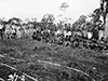
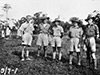
During July 1943 a group of Australians from "M" Special Unit "Operation Locust" led by Lt. A. J. Fryer trekked to Lumi to established a coastwatcher station. They were accompanied by members of Operation Whiting led by Sgt H. N. Staverman. On July 9, 1943 the members took a group photograph together. Afterwards, the members Operation Whiting left to establish a coastwatcher station near Hollandia but were later ambushed and later executed by the Japanese.
Contribute
Information
Do you have photos or additional information to add?
Last Updated
March 20, 2022
|