|
|
|
|
| Missing In Action (MIA) | Prisoners Of War (POW) | Unexploded Ordnance (UXO) |
| Chronology | Locations | Aircraft | Ships | Submit Info | How You Can Help | Donate |
|
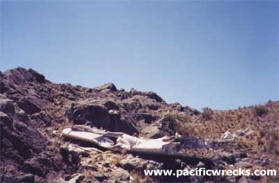 Chris Breuer 2002 |
Location Lat 5° 47' 60S Long 145° 1' 60E Mount Wilhelm has an elevation of 14,793' / 4,509m in the Bismarck Range in the Highlands of New Guinea. Also known as Mt. Wilhelm. This mountain is the highest peak in Papua New Guinea (PNG). Today, located at the point where three provinces meet: Chimbu Province (Simbu), Jiwaka Province and Madang Province in Papua New Guinea (PNG). Prewar In 1888, named by Hugo Zöller who named the Bismarck Range in honor of German Chancellor Otto von Bismarck and this peak after his son Wilhelm von Bismarck. Wartime History On May 22, 1944 around 4:00am F-7A "Under Exposed" 42-73053 crashed into Mount Wihelm at 13,000' killing the entire crew. This is the only known wartime aircraft crash onto the mountain. F-7A "Under Exposed" Serial Number 42-73052 Pilot Barstow crashed May 22, 1944 Contribute
Information Last Updated
|
Map Fallingrain |
| Discussion Forum | Daily Updates | Reviews | Museums | Interviews & Oral Histories |
|