 |
Map Viru Harbor Seized
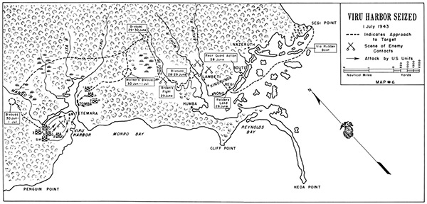
Indicates the southeast coast of New Georgia including Segi Point, Nazeruth, Boute, Regi, Nono, Kinopunda, Lambeti, Humba, Viru Harbor including Tombe and Tetemara, Mango River, Tita River, Viru Harbor. On the southern coast of New Georgia is Penguin Point, Monro Bay, Cliff Point, Reynolds Bay and Heda Point. The dotted line indicates the approach to target via rubber boat from Segi Point to Regi and overland advances westward toward Viru Harbor. The dotted line indicates the advances of the U.S. Marine Corps Raiders from the east and west in a double envelopment maneuver. To the east Walker's force of two platoons from Company P quickly capture Tombe. To the west, Company P and Company O attack Tetemara. By the early afternoon, the 4th Marine Raider Battalion, 1st Raider Regiment has secured the area and the surviving Japanese withdraw into the jungle.
Credit: USMC Date: July 1, 1943
Map
High Resolution Version
Acquire This Image |
Contribute Information
Do you have photos or additional information?
Previous Page
|
|