|
|
|
|
| Missing In Action (MIA) | Prisoners Of War (POW) | Unexploded Ordnance (UXO) |
| Chronology | Locations | Aircraft | Ships | Submit Info | How You Can Help | Donate |
|
    U.S. Army July 16, 1945 |
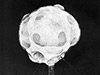
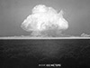
Location Lat 32° 53' 58N Long 105° 57' 37W Alamogordo is located at an elevation of 4,366' / 1,330m in Otero County of New Mexico in the United States. White Sands Missile Range (WSMR) On July 9, 1945 established as White Sands Proving Ground operated by the U.S. Army for weapons testing and was selected as the test site for the first atomic bomb code named "Trinity" and successfully detonated. Later renamed White Sands Missile Range (WSMR) when used for testing missiles and unmanned aircraft. Trinity Site On July 16, 1945 at 5:30am at Trinity Site the first atomic device "gadget" was successfully detonated atop a 100' steel tower designated ground zero with the nearest observation point 5.7 miles away with a mushroom cloud to 38,000' within seven minutes of the blast. This was the first atomic device triggered by humanity was dubbed "Trinity Site". The blast caused a crater 1 1/2 miles across and 8' deep with sand inside fused into a green glass-like solid dubbed trinitite. On December 21, 1965 Trinity Site became a National Historic district on White Sands Missile Range. Alamogordo Army Airfield (Holloman AFB) Built during early 1942 for bomber training and during 1948 renamed Holloman Air Force Base (Holloman AFB). References National Register of Historic Places Inventory - Nomination Form - Trinity Site (PDF) National Register of Historic Places Inventory - Nomination Form - Trinity Site photos (PDF) NPS White Sands National Park - Trinity Site U.S. Army White Sands Missile Range (WSM) Trinity Site Contribute
Information Last Updated
|
Map Fallingrain |
| Discussion Forum | Daily Updates | Reviews | Museums | Interviews & Oral Histories |
|