|
|
|
| Missing In Action (MIA) | Prisoners Of War (POW) | Unexploded Ordnance (UXO) |
| Chronology | Locations | Aircraft | Ships | Submit Info | How You Can Help | Donate |
|
 USN 1944 |
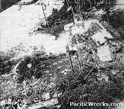
Location Lat 1° 4 minutes North, Long 154° 48 E Kapingamarangi Atoll consists is an oval shaped coral rim enclosing a lagoon 6 1/2 miles long and 4 1/2 miles wide comprised of about 30 inlets on the eastern rim. Kapingamarangi Atoll includes: Hare Island, Hepepa Island, Ueru Island, Nunakitsu Island and Rugureoru Island plus other smaller islands. Known to the British as "Greenwich Atoll" or "Pikaram Atoll" the French call it "Constantine Atoll". This atoll is roughly 480 miles south-southeast of Truk and about 440 miles southwest of Pohnpei and 200 miles northeast of New Ireland. Today, Kapingamarangi is part of Pohnpei State in the Federated States of Micronesia. Prewar After World War I, Kapingamarangi was mandated to the Japanese as part of their South Seas area. In 1935, the native population was 399 living on Hare Island and Nunakitsu Island and the islands between them. During the prewar years, Nanyo Boeki Kaisha steamers called at Kapingamarangi five times a year. World War II History During the Pacific War, used by the Japanese Navy as Kapingamarangi Seaplane Base and small ship anchorage and seaplane operating area. During 1941-1944, bombed by Allied aircraft. Occupied by the Japanese for the duration of the Pacific War. Allied missions against Kapingamarangi (Greenwich) December 15, 1941 - July 6, 1944 Kapingamarangi Lagoon (Greenwich Lagoon) The only entrance to the lagoon is through Greenwich Passage, which is divided into two channels, able to accommodate small vessels. There is a 5-knot stream in the channel during ebb tides. Most of the lagoon has depths of over 16 fathoms, but parts are obstructed by banks and coral patches. The lagoon shores at most other island are sandy. Kapingamarangi Seaplane Base Located on the western coast of Hare Island at Kapingamarangi Atoll. PB4Y-1 Liberator Bureau Number 31992 Pilot Van Voorhis crashed July 6, 1943 During the Pacific War, at least two small Japanese ships were sunk in Kapingamarangi Lagoon during November 1943: Auxiliary Minesweeper #5 and Hosho Maru. Converted Fishing Vessel Sunk in the lagoon, likely during November 1943 Unknown Vessel Sunk in the lagoon, likely during November 1943 References Naval Intelligence Division, Geographical Handbook Series, "Pacific Islands Vol IV: Western Pacific (New Guinea and Islands Northward). Produced & Printed during 1939-45 (August 1945 edition), pages 410-411 Contribute
Information Last Updated
|
Map 1945 |
| Discussion Forum | Daily Updates | Reviews | Museums | Interviews & Oral Histories |
|