|
|
|
| Missing In Action (MIA) | Prisoners Of War (POW) | Unexploded Ordnance (UXO) |
| Chronology | Locations | Aircraft | Ships | Submit Info | How You Can Help | Donate |
|
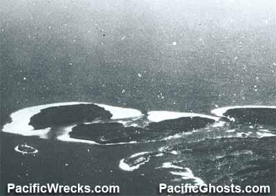 USN October 11, 1943  Justin Taylan 2003 |
Location Tuha Channel (Tuha Bay) borders Shortland Island and Korovou (Korouvo) to the north, northwest and west. Poporang Island is located to the east and south. Magusaiai is to the west-southwest. To the northeast is Shortland Harbor and Faisi Island. Inside Tuha Channel is Kerunepua Island. Inside Tuha Channel is Kerunepua Island. Wartime History Tuha Channel was used by the Japanese an anchorage and seaplane operating area for Shortland Harbor Seaplane Base (Tuha Channel). During 1942–1943 seaplanes and flying boats were moored at this location. Allied missions against Shortland Harbor (Tuha Channel) May 6, 1942–May 15, 1944 Contribute
Information Last Updated
|
Map April 11, 1943 Map April 19, 1943 |
| Discussion Forum | Daily Updates | Reviews | Museums | Interviews & Oral Histories |
|