Missing In Action (MIA)
Prisoners Of War (POW)
Unexploded Ordnance (UXO)
Chronology
Locations
Aircraft
Ships
Submit Info
How You Can Help
Donate
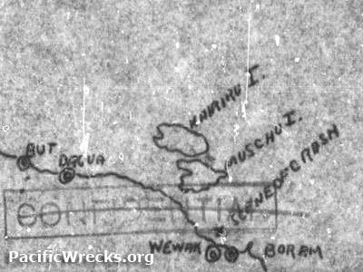
Map depicting the approximate location of the loss of
B-25D 41-30319
Annotations include a black line indicating the north coast of
New Guinea
with
But
,
Dagua
,
Wewak
and
Boram
indicated and offshore islands
Muschu Island
and
Kairiru Island
.
Credit: MACR 13282 page 13 Date:
September 2, 1943
Map
High Resolution Version
Acquire This Image
|
Contribute Information
Do you have photos or additional information?
Previous Page
Discussion Forum
Daily Updates
Reviews
Museums
Interviews & Oral Histories
Pacific Wrecks Inc.
All rights reserved.