|
|
|
|
| Missing In Action (MIA) | Prisoners Of War (POW) | Unexploded Ordnance (UXO) |
| Chronology | Locations | Aircraft | Ships | Submit Info | How You Can Help | Donate |
|
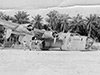 USAAF 1944  Pat Tasker 2009 |
Location Lat 9° 0' 24" S Long 158° 2' 12" W Penrhyn Airfield is located at an elevation of 8' above sea level at the southern end of Penrhyn Island in the Cook Islands. The runway nearly spans the width of the narrow island. Also known as "Penrhyn Island Airfield" or "Robinson Field". Still in use today as Tongareva Airport. Construction Built by the Americans during November 1942. A single runway was completed during late 1942 or early 1943. Later, named "Robinson Field". Wartime History During the Pacific War, Penrhyn Airfield was part of the more easterly ferry route from Hawaii the South Pacific (South Pacific Route No. 2) located between Hickam Field 2,099 miles away and the next leg Aitutaki Airfield located 688 miles away. Established as "Station 16" in Army Air Corps Ferrying Command. Later, operated by the Pacific Wing of Air Transport Command (ATC), 1526th Army Air Force Base Unit (1526th AAFBU). This airfeild was supplied by U.S. Army Air Force (USAAF) C-87 Liberator Express on the "milk run" delivered mail and supplies. By August 1944, the route was taken over by the U.S. Navy (USN) for the remainder of the Pacific War. Today Still in use today as Tongareva Airport with a single runway oriented 14/32 measures 5,577' / 1,700 meters. Airport codes: ICAO: NCPY IATA: PYE. B-24D "Go Gettin' Gal" Serial Number 42-40253 Wreckage abandoned at the airfield References Armed Forces In World War II page 183–184 Cook Islands Airports - Penrhyn Airport official website "The Penrhyn runway was built during World War 2 as part of the allied military initiative along with Aitutaki and Tonga to create an alternative Eastern war time supply route from Hawaii through to Australia and New Zealand. The compacted coral runway was originally nearly 3000 metres long but has since been shortened. The airstrip stretches along a narrow motu (islet) next to the village of Omoka." Contribute
Information Last Updated
|
Map Fallingrain |
| Discussion Forum | Daily Updates | Reviews | Museums | Interviews & Oral Histories |
|